
By Matthew Ball, Anglo European School
Citation
Ball, M. (2021) The role of tectonic setting and country development on volcanic risk. Routes 1(3): 263-274.
Abstract
This article addresses the role that tectonic setting and country development hold in determining the scale of volcanic risk. It can widely be established that both tectonic setting and country development act as the key basis for determining the risk associated with volcanic hazards, from which other factors build upon. Through analysis of historic and modern eruptions, the complexity that underpins volcanic risk is highlighted, with the connections between tectonic setting and country development being central to this. It is this connection that serves as the basis for this paper.
Key terms
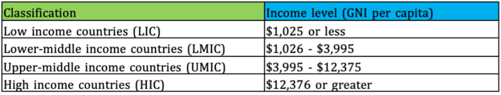
I will be considering country development on an economic level and will be using the World Bank’s classifications(World Bank Country and Lending Groups – World Bank Data Help Desk, 2020) – see table 1 below.
I will also be defining ‘risk’ as the likelihood of a person or property to be injured/killed/damaged etc. by a hazard (Safety on volcanoes: volcanic risk and risk zones around volcanoes, n.d.). Therefore, explosivity of the eruption, population proximity, awareness of the hazard, level of prediction and associated planning and preparation measures are all factors needing to be considered.
1. Introduction
A key focus of this essay is how volcanic activity varies according to tectonic setting. The tectonic settings in question are; constructive plate boundaries, destructive plate boundaries and areas of hot spot activity.
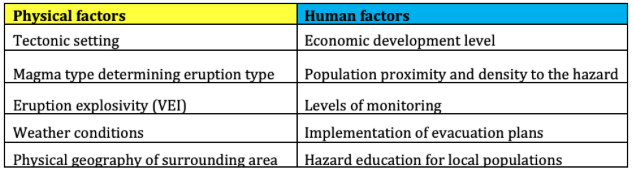
Table 2 below outlines the key human and physical factors that influence volcanic risk. Physical factors relate to environmental processes of the earth, while human factors are related to people’s behaviour (Rogers, Castree and Kitchin, 2013).
This essay aims to explore the relative role of tectonic setting and country development on volcanic risk. This will be specifically achieved through the analysis of case examples, with each illustrating the interconnection present between tectonic setting and country development.
2. Physical geography background
Constructive plate boundaries are characterised by two tectonic plates diverging away from one another as a result of rising convection currents. At oceanic-oceanic constructive plate boundaries, this results in magma rising up from the mantle in-between the plates and typically forming mid-ocean ridges (Wilson, 2007).
At continental-continental constructive plate boundaries, the convection currents are too weak to cause the plate to cleanly break and therefore, as the plate is arched upwards, faults occur typically leading to the formation of a rift valley (King, n.d. a). Both forms of constructive plate boundary commonly feature shield volcanoes (Decker and Decker, 2020).
At destructive plate boundaries, two plates move towards one another leading to collisions (King, n.d. b). At oceanic-continental destructive boundaries the oceanic plate subducts underneath the less-dense continental plate and magma rises up through weaknesses in the continental plate which typically form stratovolcanoes and calderas (Decker and Decker, 2020). The same subduction process occurs at oceanic-oceanic destructive boundaries, with the older and denser oceanic plate of the two being subducted (King, n.d. a). As this type of boundary develops eruptions occur closer to the ocean’s surface and island chains can form (King, n.d. b).
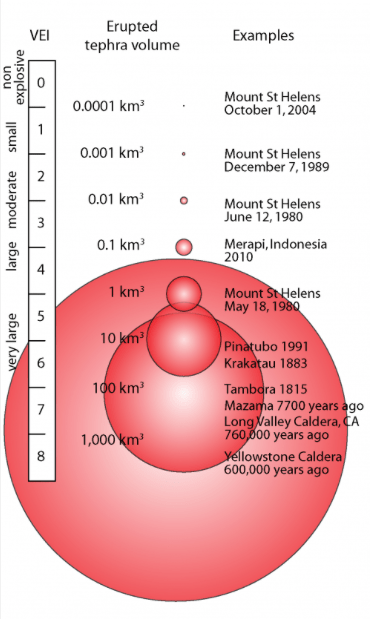
Finally, hot spot volcanism is unique as it does not occur at plate boundaries and rather occurs at abnormally hot regions within the mantle that are created by mantle plumes. Mantle plumes are convections of abnormally hot rock in the mantle that leads to the melting of tectonic plates and the formation of volcanoes (Hot Spot Volcanism, 2014). The explosivity of volcanic eruptions is most commonly measured using the Volcanic Explosivity Index (VEI). It is a logarithmic scale, in which each interval represents a tenfold increase in observed ejected material. The index is illustrated in figure 1 below.
The explosivity of volcanic eruptions is what determines the nature of their primary volcanic hazards – the hazards formed directly be the eruptions themselves (Hamdan, 2013). The primary hazards of explosive eruptions are fast-moving pyroclastic flows (flows of lava pieces, ash and gases) (Pyroclastic Flows, 2019) alongside ash clouds (Gouhier et al., 2019). Effusive eruptions are gentler, as a result of the reduced pressure and feature lava flows as their primary hazard (Tsang, Lindsay, Coco and Deligne, 2020). Therefore, a higher VEI rating is associated with more dangerous eruptions, due to the greater risk of widespread harm and damage that pyroclastic flows and ash clouds pose over lava flows (Riley, n.d.). Depending on the volcano’s setting, secondary volcanic hazards – hazards indirectly caused by the eruption – can follow (Hamdan, 2013). These include tsunamis, lahars – which are rapid flows of water, mud and rock fragments (Pierson, Wood and Driedger, 2014) – , outbreaks of disease and famine (Hamdan, 2013).
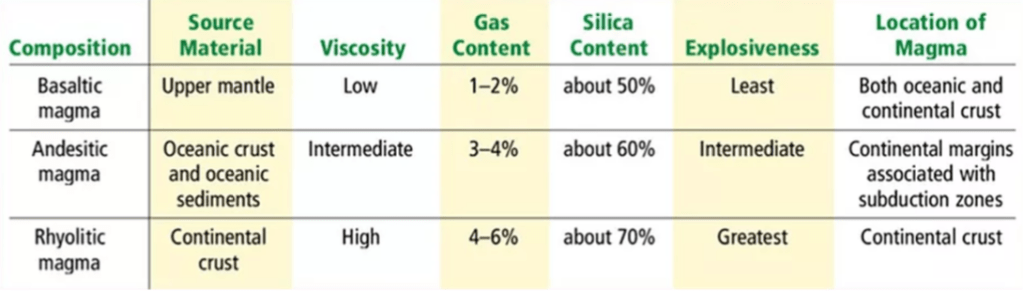
The nature and explosivity of volcanic eruptions are highly determined by magma type and its associated silica and dissolved gas content (Cassidy, Manga, Cashman and Bachmann, 2018). Table 3 below shows the three main types of magma, alongside their characteristics. Low-silica content magma is typically seen at constructive plate boundaries and hot spots, due to the partial melting of mantle rocks (Geological Society – Viscosity of Magmas, n.d.). In comparison, at destructive plate boundaries, the partial melting of high silica content crustal rocks leads to silica-rich magmas forming (Geological Society – Viscosity of Magmas, n.d.). The viscosity of magma largely determines the explosivity of the eruption, with gas struggling to escape highly viscous magma causing pressure, and subsequently explosivity, to build as a result (Cassidy, Manga, Cashman and Bachmann, 2018).
3. Case studies
3.1. Volcanic risk on constructive plate boundaries – Eyjafjallajokull and Nyiragongo
HICs (high-income countries) can experience severe impacts from volcanic eruptions, highlighting tectonic setting’s importance in determining volcanic risk over country development level. A recent example is the 2010 eruption of Eyjafjallajokull, located in Iceland across the Mid Atlantic Ridge (a constructive plate margin) (Geirsson et al., 2006). The effusive eruption measured at VEI 3 (Gudmundsson et al., 2012), however, the impacts were felt across Northern and Western Europe, America and Iceland itself (Ellertsdottir, 2014.). The ash, which was carried across Europe, disrupted air travel, entertainment and food exports – with the crisis lasting for 2 weeks (An Inconvenient Plume – The Eruption of Eyjafjallajokull, Iceland, 2011). The eruption signifies how the interconnectedness of HICs with the rest of the world by air travel can be suddenly disrupted by eruptive activity (Choi, 2012). The eruption also highlights the significance of other physical factors alongside tectonic setting. The caldera is located underneath an ice cap (Gerard Davies et al., 2020), which caused water to mix with the magma during the eruption, resulting in the explosivity increasing (Klemetti, 2011) while the polar front jet stream was the main driving force for the ash’s distribution (Handwerk, 2010). As a result, when assessing the factors contributing to volcanic risk a focus on the interconnection present between both physical and human factors is needed. The 2010 eruption of Eyjafjallajokull is a key example of such interconnection and highlights the challenges that can arise through the unpredictability it holds.
Alternatively, the 2002 Nyiragongo eruption is a clear example of how country development can be viewed as more important than tectonic setting. Occurring at a constructive boundary (Turgen, 2014), the eruption measured at just 1 on the VEI scale (Volcanic Explosivity Index (VEI), n.d.) and yet resulted in over 45 deaths in the first 24 hours (Case study: volcanic eruption, n.d.), reaching a total of 170 as a result of secondary hazards (Tedesco et al. 2007). Nyiragongo is located in the Democratic Republic of Congo, a low-income country (Congo, Dem. Rep. | Data, n.d.) that has been suffering from corruption (DR Congo Corruption Report, 2016) and conflict for decades (Violence in the Democratic Republic of Congo, 2020). The poverty that faced the majority of the population placed them in a vulnerable position for the secondary impacts that followed. Cholera risk increased significantly following the eruption as water sources became contaminated, only being prevented by rapid intervention from NGOs in the area (Baxter and Ancia, 2002). Both the political instability within the Democratic Republic of Congo, alongside its status as an LIC, acted to hinder efforts to reduce volcanic risk. The lack of a functioning government has been attributed to the lack of evacuation in nearby city Goma (Clarke, 2002), while the Volcano Disaster Assistance Program stated that just 2 volcanologists were studying Nyiragongo prior to its 2002 eruption (Clarke, 2002). The eruption therefore, is a clear example of the amplifying impact that poor governance has on volcanic risk, with the death toll highlighting the necessity of implementing effective hazard education programmes and local evacuation plans.
3.2. Volcanic risk on destructive plate boundaries – Mt. St. Helens, White Island and Pinatubo
In comparison to Nyiragongo, the 1980 eruption of Mt. St Helens in the USA resulted in 57 deaths (Bagley, 2018) despite being a VEI 5 eruption (MSH Comparisons With Other Eruptions [USGS], 1997). The differences highlight how susceptibility to volcanic hazards is increased as a result of lower country development and greater population proximity. Although Nyiragongo is cited as one of the most active volcanoes (Valade et al., 2020), it is rarely studied – as it is inside a warzone and Congolese volcanologists receive limited funding (Sumner, 2014). This heightens the severity of eruptions in the area – with a lack of education and safety precautions increasing overall threat levels. Greater development level also enables local populations the ‘choice’ to locate away from the hazard – with the closest major city to Mt. St Helens being Portland, 83.6 km away (Cities Near Me – Mount Saint Helens | Travelmath, 2020). This is compared to Goma, located 15.5km away from Nyiragongo, where lava flows reached in less than a day (Seach, 2020) with 350,000 of the around 500,000 population being affected by the eruption in 2002 (Seach, 2020). The Mt. St Helens eruption therefore highlights the hugely advantageous position that high-income countries are in regarding reducing volcanic risk. HICs are able to develop around volcanic hazards, which is an invaluable ability that isn’t possible in LICs where economic development is lower. As a result, hazard preparation measures in LICs become even more vital – as they represent the first line of protection from volcanic events for residents living there.
The 2019 eruption of White Island, in New Zealand, bucks the trend regarding both volcanic risk related to country development and population proximity. White Island is currently New Zealand’s most active stratovolcano, located just off the east coast of New Zealand’s North Island (Pickrell, 2019). It’s uninhabited (Sherburn, Scott, Nishi and Sugihara, 1998), yet tourists can visit the island by boat or take a helicopter/plane ride across (White Island – Travel guide at Wikivoyage, 2019). Prior to the December 2019 eruption, the island’s volcanic alert level was raised to level 2 (the highest possible without an eruption taking place) following signs of volcanic unrest (Morton, 2019), yet the eruption itself was unpredicted by the sensors on the island (Molteni, 2019). The eruption coincided with 47 tourists being on the island, resulting in 21 deaths (Perry, 2020). The paramount issue highlighted by the event is one of governmental ignorance. Irrespective of prediction failures closer to the eruption, the New Zealand government went against expert advice for years, allowing tours to be run despite the growing risks of an eruption (Peters, 2019). Therefore, with the risk being well documented for years, no excuse can be made for the loss of life that occurred and the White Island eruption highlights again the ramifications of poor governance regarding volcanic risk.
The eruption of Pinatubo in 1991 measured as a 6 on the VEI scale (Witze, 2018), the event killed 772 people and left 200,000 people homeless as a result of pyroclastic flows alongside the lahars that followed (Jennings, 2018). Pinatubo is an example of a stratovolcano, typically featuring dacite magma (Pinatubo, Philippines, n.d.) that causes such violent eruptions. The Aeta people that inhabited the slopes of the volcano (Marler, 2011) held strong religious beliefs and resulting fatalist attitudes on the severity of a volcanic hazard. Despite limited attempts at education from government officials (Surviving the Eruption at Mt. Pinatubo, 2005), an unknown number of Aeta refused to leave and died as a result (Gaillard, 2007). The lack of effective education on volcanic hazards provided to the Aeta saw their local religious beliefs upheld, which when combined with their attachment to their native homes, took precedence over the effective evacuation plans that were communicated in local areas (Pappas, 2011). Therefore, the 1991 Pinatubo eruption highlights how volcanic risk reduction is constrained by both economic and governmental factors as well as the underlying social perceptions held by local communities (Gaillard, 2008).
3.3. Volcanic risk on hotspots – Yellowstone and Kilauea
Plate boundaries can also have little impact on volcanic risk, such as areas of hotspot activity, that occur away from plate boundaries. The Yellowstone supervolcano situated in Yellowstone National Park, Wyoming, USA (White, Hutchinson and Keith, 1988) is formed through rising magma plumes instead of plate boundaries and tectonics, lying away from any known fault lines yet atop a continental hotspot (Smith and Braile, 1994). Despite this, the volcano has been predicted to have the potential to release a super eruption (an eruption rated VEI 8 or higher), which would impact the entire world through the ash clouds and lava emitted (Mastin, Eaton and Lowenstern, 2014). Subsequently, the potential of a super-eruption illustrates how both plate boundaries can be limited in determining the severity of all volcanic activity – with other factors such as hotspot theory also needing to be considered – and how economic development can be limited in reducing volcanic risk and impact, in face of high magnitude eruption events.
Contrastingly, Hawaii is another area notorious for its hotspot activity, featuring daily eruptions between VEI 0-2 (Global Volcanism Program | Kilauea, n.d.), reaching into VEI 4 at its peak in 1790 (Global Volcanism Program | Kilauea, n.d.). Therefore, the area poses a reduced risk to life compared to destructive boundaries, with eruptions being well expected and prepared for – to the extent that Kilauea experiences ‘eco-tourism’ (Toth Fox, 2012). Kilauea is a shield volcano (Bagley, 2018), with the low-silica basaltic lava present here being of reduced silica content, meaning it’s less viscous and eruptions are generally effusive due to the reduced gas content of the lava (Geological Society – Viscosity of Magmas, n.d.). Kilauea highlights the major significance that tectonic setting can hold in determining both the overall explosivity and subsequent area of effect of eruptions. In contrast to Yellowstone, areas that feature low magnitude eruptions – such as Kilauea – volcanic risk can be managed far more successfully through measures related to economic development, such as frequent monitoring – with the 20 years of historical measures at the volcano now allowing for precise eruption forecasting (Klein, 1984) – alongside the development of evacuation plans.
4. Discussion
A key point to establish is that tectonic setting itself is not the sole factor that has to be analysed when entering a discussion surrounding volcanic risk. Tectonic setting acts to provide the characteristics of the eruption, beyond this however, there are plenty of observed factors that work alongside one another to establish the overall volcanic risk an area experiences.
Country development is one such determining factor of volcanic risk. As seen through the case study examples, there is a general trend towards HICs being more able to mitigate the hazards of volcanic activity. They typically have the resources to establish monitoring technology, implement effective evacuation plans, alongside the local population’s ability to relocate away from volcanic hazards. Contrastingly, LICs often suffer from limited monitoring, a lack of education surrounding volcanic risk, and hold a limited ability to relocate away from hazards – related to the low level of development they experience.
Crucially, there are exceptions to these trends. The vast impact of the 2012 Eyjafjallajökull eruption for example, which despite being an effusive eruption and occurring in an HIC substantially impacted the entirety of Europe, both economically and socially, for numerous weeks. The 2019 White Island eruption, which signifies the critical shortcoming of development, in instances of unsuccessful monitoring, in relation to reducing volcanic risk. Finally, Yellowstone– holding the potential of a super eruption, highlights the challenges high magnitude volcanic events pose – even in areas of high development.
5. Conclusion
While this essay explores two connected factors pertaining to volcanic risk in isolation, the complexity of volcanic hazards should be stressed. This review highlights that volcanic risk assessments need to take into account both the local physical and social contexts, and therefore should involve volcanologists who understand the physical processes alongside social scientists with local expertise to recognise who may be most vulnerable in a volcanic crisis.
6. References
Bagley, M., 2018. Kilauea Volcano: Facts About The 30-Year Eruption. [online] Live Science. Available at: <https://www.livescience.com/27622-kilauea.html> [Accessed 7 August 2020].
Bagley, M., 2018. Mount St. Helens Eruption: Facts & Information. [online] livescience.com. Available at: <https://www.livescience.com/27553-mount-st-helens-eruption.html> [Accessed 4 August 2020].
Baxter, P. and Ancia, A., 2002. Human Health And Vulnerability In The Nyiragongo Volcano Crisis DR Congo Jun 2002 – Democratic Republic Of The Congo. [online] ReliefWeb. Available at: <https://reliefweb.int/report/democratic-republic-congo/human-health-and-vulnerability-nyiragongo-volcano-crisis-dr-congo> [Accessed 4 August 2020].
Cassidy, M., Manga, M., Cashman, C. and Bachmann, O., 2018. Controls On Explosive-Effusive Volcanic Eruption Styles. [online] Nature. Available at: <http://10.1038/s41467-018-05293-3> [Accessed 7 August 2020].
Choi, C., 2012. Why Iceland Volcano’s Eruption Caused So Much Trouble. [online] livescience.com. Available at: <https://www.livescience.com/31127-iceland-volcano-ash-plume-trouble.html> [Accessed 4 August 2020].
Clarke, T., 2002. Seismic Rumbling Foretold Congo Eruption. [online] Nature. Available at: <https://www.nature.com/articles/415353a> [Accessed 7 August 2020].
Curriculum Press. 2011. An Inconvenient Plume – The Eruption Of Eyjafjallajokull, Iceland. [online] Available at: <https://curriculum-press.co.uk/resources/an-inconvenient-plume-the-eruption-of-eyjafjallajokull-iceland> [Accessed 4 August 2020].
Datahelpdesk.worldbank.org. 2020. World Bank Country And Lending Groups – World Bank Data Help Desk. [online] Available at: <https://datahelpdesk.worldbank.org/knowledgebase/articles/906519-world-bank-country-and-lending-groups> [Accessed 4 August 2020].
Decker, R. and Decker, B., 2020. Volcanoes Related To Plate Boundaries. [online] Encyclopedia Britannica. Available at: <https://www.britannica.com/science/volcano/Volcanoes-related-to-plate-boundaries> [Accessed 7 August 2020].
Doocy, S., Daniels, A., Dooling, S. and Gorokhovich, Y., 2013. The Human Impact Of Volcanoes: A Historical Review Of Events 1900-2009 And Systematic Literature Review. [online] Available at: <http://currents.plos.org/disasters/index.html%3Fp=7389.html> [Accessed 7 August 2020].
Ellertsdottir, E., 2014. EYJAFJALLAJÖKULL AND THE 2010 CLOSURE OF EUROPEAN AIRSPACE: CRISIS MANAGEMENT, ECONOMIC IMPACT, AND TACKLING FUTURE RISKS. [online] Tcd.ie. Available at: <https://www.tcd.ie/Economics/assets/pdf/SER/2014/elin_thora.pdf> [Accessed 4 August 2020].
En.wikivoyage.org. 2019. White Island – Travel Guide At Wikivoyage. [online] Available at: <https://en.wikivoyage.org/wiki/White_Island#:~:text=White%20Island%20(Maori%3A%20Whakaari),overfly%20on%20fixed%2Dwing%20aircraft> [Accessed 4 August 2020].
Ete.cet.edu. n.d. Volcanic Explosivity Index (VEI). [online] Available at: <http://ete.cet.edu/gcc/?/volcanoes_explosivity/> [Accessed 4 August 2020].
Gaillard, J., 2007. Traditional Societies’ Response To Volcanic Hazards In The Philippines. [online] bioone.org. Available at: <https://doi.org/10.1659/mrd.0949> [Accessed 4 August 2020].
Gaillard, J., 2008. Alternative Paradigms Of Volcanic Risk Perception: The Case Of Mt. Pinatubo In The Philippines. [online] Science Direct. Available at: <https://www.sciencedirect.com/science/article/abs/pii/S0377027307004234> [Accessed 7 August 2020].
GAN Integrity. 2016. DR Congo Corruption Report. [online] Available at: <https://www.ganintegrity.com/portal/country-profiles/democratic-republic-of-the-congo/> [Accessed 4 August 2020].
Geirsson, H., Árnadóttir, T., Völksen, C., Jiang, W., Sturkell, E., Villemin, T., Einarsson, P., Sigmundsson, F. and Stefánsson, R., 2006. Current Plate Movements Across The Mid‐Atlantic Ridge Determined From 5 Years Of Continuous GPS Measurements In Iceland. [online] AGU. Available at: <https://agupubs.onlinelibrary.wiley.com/doi/abs/10.1029/2005JB003717> [Accessed 7 August 2020].
Geolsoc.org.uk. n.d. Geological Society – Viscosity Of Magmas. [online] Available at: <https://www.geolsoc.org.uk/ks3/gsl/education/resources/rockcycle/page3655.html> [Accessed 4 August 2020].
Gerard Davies, A., Chien, S., Doubleday, J., Tran, D., Thordarson, T., Gudmundsson, M., Höskuldsson, S., Jakobsdóttir, S., Wright, R. and Mandl, D., 2020. Observing Iceland’s Eyjafjallajökull 2010 Eruptions With The Autonomous NASA Volcano Sensor Web. [online] AGU. Available at: <https://agupubs.onlinelibrary.wiley.com/doi/full/10.1002/jgrb.50141> [Accessed 7 August 2020].
Global Conflict Tracker. 2020. Violence In The Democratic Republic Of Congo. [online] Available at: <https://www.cfr.org/global-conflict-tracker/conflict/violence-democratic-republic-congo> [Accessed 4 August 2020].
Gouhier, M., Eychenne, J., Azzaoui, N., Guillin, A., Deslandes, M., Poret, M., Costa, A. and Husson, P., 2019. Article Open Access Published: 05 February 2019 Low Efficiency Of Large Volcanic Eruptions In Transporting Very Fine Ash Into The Atmosphere. [online] Nature. Available at: <https://dx.doi.org/10.1038%2Fs41598-019-38595-7> [Accessed 7 August 2020].
Gudmundsson, M., Thordarson, T., Höskuldsson, Á. et al., 2012. Ash generation and distribution from the April-May 2010 eruption of Eyjafjallajökull, Iceland. [online] Nature.com. Available at: <https://doi.org/10.1038/srep00572> [Accessed 4 August 2020]
Hamdan, I., 2013. Volcanic Hazards. [online] Sierra.sitehost.iu.edu. Available at: <https://sierra.sitehost.iu.edu/papers/2013/hamdan.pdf> [Accessed 4 August 2020].
Handwerk, B., 2010. Iceland Volcano Has “Quieted Down”—Ash Crisis To End?. [online] National Geographic. Available at: <https://www.nationalgeographic.com/news/2010/4/100419-iceland-volcano-eyjafjallajokull-eruption-ash-plume-changing/> [Accessed 4 August 2020].
IrideScience. 2020. Rhyolitic Magma | Types Of Magma. [online] Available at: <https://iridescienceee.wixsite.com/website-5/single-post/2017/12/14/Rhyolitic-Magma-Types-of-Magma> [Accessed 4 August 2020].
Jennings, R., 2018. The Odd Positive Impact Of Mount Mayon’s Volcanic Eruption In The Philippines. [online] Forbes. Available at: <https://www.forbes.com/sites/ralphjennings/2018/02/06/lessons-learned-philippine-disaster-officials-double-down-at-the-mayon-volcano/#a4098663095e> [Accessed 7 August 2020].
King, H., n.d. a Divergent Plate Boundaries – Divergent Boundary. [online] Geology.com. Available at: <https://geology.com/nsta/divergent-plate-boundaries.shtml#:~:text=Divergent%20Plate%20Boundary%20%2D%20Continental,through%20the%20thick%20plate%20material> [Accessed 4 August 2020].
King, H., n.d. b Convergent Plate Boundaries – Convergent Boundary. [online] Geology.com. Available at: <https://geology.com/nsta/convergent-plate-boundaries.shtml> [Accessed 4 August 2020].
Klein, F., 1984. Eruption Forecasting At Kilauea Volcano, Hawaii. [online] AGU. Available at: <https://agupubs.onlinelibrary.wiley.com/doi/abs/10.1029/JB089iB05p03059> [Accessed 7 August 2020].
Klemetti, E., 2011. Hydrovolcanism: When Magma And Water Mix. [online] Discover Magazine. Available at: <https://www.discovermagazine.com/the-sciences/hydrovolcanism-when-magma-and-water-mix> [Accessed 7 August 2020].
Marler, T., 2011. The Aeta – Pinatubo Loop. [online] Taylor & Francis. Available at: <https://www.tandfonline.com/doi/abs/10.4161/cib.16973> [Accessed 7 August 2020].
Molteni, M., 2019. Why Volcanologists Didn’t Predict New Zealand’s Deadly Eruption. [online] Wired. Available at: <https://www.wired.com/story/why-volcanologists-didnt-predict-new-zealands-deadly-eruption/> [Accessed 4 August 2020].
Morton, J., 2019. White Island Eruption: Scientists Defend Volcano Warning System Amid Criticism. [online] NZ Herald. Available at: <https://www.nzherald.co.nz/nz/news/article.cfm?c_id=1&objectid=12292904> [Accessed 7 August 2020].
National Geographic Society. 2014. Hot Spot Volcanism. [online] Available at: <https://www.nationalgeographic.org/article/hot-spot-volcanism/> [Accessed 4 August 2020].
National Geographic Society. 2019. Pyroclastic Flows. [online] Available at: <https://www.nationalgeographic.org/encyclopedia/pyroclastic-flow/> [Accessed 4 August 2020].
Pappas, S., 2011. Pinatubo: Why The Biggest Volcanic Eruption Wasn’t The Deadliest. [online] Live Science. Available at: <https://www.livescience.com/14603-pinatubo-eruption-20-anniversary.html> [Accessed 7 August 2020].
Perry, N., 2020. Death Toll From New Zealand Volcano Rises As Victim Dies From Injuries Nearly Two Months Later. [online] The Independent. Available at: <https://www.independent.co.uk/news/world/australasia/white-island-volcano-death-toll-twenty-one-new-zealand-auckland-a9307716.html> [Accessed 7 August 2020].
Pickrell, J., 2019. Why Deadly New Zealand Volcano Eruption Was Hard To Predict. [online] Nature. Available at: <https://www.nature.com/articles/d41586-019-03819-3> [Accessed 7 August 2020].
Pierson, T., Wood, N. and Driedger, C., 2014. Reducing Risk From Lahar Hazards: Concepts, Case Studies, And Roles For Scientists. [online] BMC. Available at: <https://doi.org/10.1186/s13617-014-0016-4> [Accessed 7 August 2020].
Pubs.usgs.gov. 1997. MSH Comparisons With Other Eruptions [USGS]. [online] Available at: <https://pubs.usgs.gov/gip/msh/comparisons.html> [Accessed 4 August 2020].
Pubs.usgs.gov. n.d. Understanding Plate Motions [This Dynamic Earth, USGS]. [online] Available at: <https://pubs.usgs.gov/gip/dynamic/understanding.html#:~:text=Divergent%20boundaries%20occur%20along%20spreading,away%20from%20the%20ridge%20crest> [Accessed 4 August 2020].
Riley, C., n.d. Volcanic Hazards. [online] Geo.mtu.edu. Available at: <http://www.geo.mtu.edu/volcanoes/hazards/primer/> [Accessed 4 August 2020].
Rogers, A., Castree, N. and Kitchin, R., 2013. A Dictionary Of Human Geography. [online] Oxford Reference. Available at: <https://www.oxfordreference.com/view/10.1093/acref/9780199599868.001.0001/acref-9780199599868> [Accessed 7 August 2020].
Seach, J., 2020. Nyiragongo Volcano Eruption 2002. [online] Nyiragongo.com. Available at: <http://nyiragongo.com/2002.html> [Accessed 4 August 2020].
Sherburn, S., Scott, B., Nishi, Y. and Sugihara, M., 1998. Seismicity At White Island Volcano, New Zealand: A Revised Classification And Inferences About Source Mechanism. [online] Science Direct. Available at: <https://www.sciencedirect.com/science/article/abs/pii/S0377027398000225> [Accessed 7 August 2020].
Smith, R. and Braile, L., 1994. The Yellowstone Hotspot. [online] Science Direct. Available at: <https://www.sciencedirect.com/science/article/abs/pii/0377027394900027> [Accessed 7 August 2020].
Smithsonian Institution | Global Volcanism Program. n.d. Global Volcanism Program | Kilauea. [online] Available at: <https://volcano.si.edu/volcano.cfm?vn=332010&vtab=Eruption> [Accessed 4 August 2020].
Sumner, T., 2014. Studying A Volcano In A War Zone. [online] Science News. Available at: <https://www.sciencenews.org/article/studying-volcano-war-zone> [Accessed 4 August 2020].
Surviving the Eruption at Mt. Pinatubo. 2005. [film] Directed by G. Harvey. National Geographic.
Tedesco, D., Vaselli, O., Papale, P., Carn, S. A.,Voltaggio, M., Sawyer, G. M., Durieux, J., Kasereka, M., and Tassi, F., 2007, January 2002 volcano‐tectonic eruption of Nyiragongo volcano, Democratic Republic of Congo. [online] AGU. Available at: <https://doi.org/10.1029/2006JB004762> [Accessed 4 August 2020]
Toth Fox, C., 2012. Ecotourism On Hawaii Island – Hawaii Business Magazine. [online] Hawaii Business Magazine. Available at: <https://www.hawaiibusiness.com/ecotourism-on-hawaii-island/> [Accessed 4 August 2020].
Travelmath.com. 2020. Cities Near Me – Mount Saint Helens | Travelmath. [online] Available at: <https://www.travelmath.com/cities-near/Mount+Saint+Helens> [Accessed 4 August 2020].
Tsang, S., Lindsay, J., Coco, G. and Deligne, N., 2020. The Influence Of Surficial Features In Lava Flow Modelling. [online] BMC. Available at: <https://doi.org/10.1186/s13617-020-00095-z> [Accessed 7 August 2020].
Turgen, A., 2014. Plate Tectonics And Volcanic Activity. [online] National Geographic Society. Available at: <https://www.nationalgeographic.org/article/plate-tectonics-volcanic-activity/> [Accessed 4 August 2020].
Valade, S., Ripepe, M., Giuffrida, G., Karume, K. and Tedesco, D., 2020. Dynamics Of Mount Nyiragongo Lava Lake Inferred From Thermal Imaging And Infrasound Array. [online] Science Direct. Available at: <https://www.sciencedirect.com/science/article/pii/S0012821X18304631> [Accessed 7 August 2020].
Volcano.oregonstate.edu. n.d. Pinatubo, Philippines. [online] Available at: <http://volcano.oregonstate.edu/vwdocs/volc_images/southeast_asia/philippines/pinatubo.html> [Accessed 4 August 2020].
Volcanodiscovery.com. n.d. Safety On Volcanoes: Volcanic Risk And Risk Zones Around Volcanoes. [online] Available at: <https://www.volcanodiscovery.com/volcanic_risk.html> [Accessed 4 August 2020].
Volcanoes.usgs.gov. 2016. USGS: Volcano Hazards Program Glossary – VEI. [online] Available at: <https://volcanoes.usgs.gov/vsc/glossary/vei.html#:~:text=The%20scale%20is%20logarithmic%2C%20with,VEI%201%20and%20VEI%202> [Accessed 4 August 2020].
White, D., Hutchinson, R. and Keith, T., 1988. The Geology And Remarkable Thermal Activity Of Norris Geyser Basin, Yellowstone National Park, Wyoming. [online] USGS. Available at: <https://pubs.er.usgs.gov/publication/pp1456> [Accessed 7 August 2020].
Wilson, M., 2007. Mid-Ocean Ridges. [online] Springer Link. Available at: <https://doi.org/10.1007/978-94-010-9388-0_5> [Accessed 7 August 2020].
Witze, A., 2018. Volcanologists Warn World Is Unprepared For Next Major Eruption. [online] Nature. Available at: <https://www.nature.com/articles/d41586-018-02784-7> [Accessed 7 August 2020].
World Bank. n.d. Congo, Dem. Rep. | Data. [online] Available at: <https://data.worldbank.org/country/congo-dem-rep> [Accessed 4 August 2020].
#Write for Routes
Are you 6th form or undergraduate geographer?
Do you have work that you are proud of and want to share?
Submit your work to our expert team of peer reviewers who will help you take it to the next level.
Related articles
