
By Alicia Smith, Trinity Sixth Form Academy (now studying at University of Hull)
Citation
Smith, A. (2021) The impacts and management of flooding in the upper course of the Calder Valley. Routes 2(1): 1-9
Abstract
The Calder Valley is a drainage basin in West Yorkshire, UK. This essay will highlight the causes and impacts of flooding in the upper course of the valley. It will then evaluate the responses to two recent major flooding events in 2015 and 2020. This essay draws on journalistic reports, interviews with residents and business owners, and the work of academic geographers in order to make this assessment. Based on this evaluation, two recommendations are made for future successful management of flooding in the Calder Valley. I conducted two interviews with people that were directly impacted by these flooding events. The interviewees made a number of suggestions for what could be improved within the area in order to increase the protection of their property after the flooding events. The key findings of this essay are that the flood management strategies that have been put in place within the Calder Valley are not effectively protecting and reducing the risk of flooding within this area. There are two recommendations that I have made which would help to protect the Calder Valley from flooding: 1. Completion of the ongoing hard engineering strategies; 2. Ensuring that there is more support put in place for community level management strategies.
1. Introduction
The Calder Valley is a drainage basin in West Yorkshire (Figure 1 and 2). It regularly experiences flooding due to a combination of topography, high levels of antecedent rainfall, and a high degree of urbanisation along the valley floor. The upper course of the River Calder has a very steep relief with an elevation of 400m. This essay will establish causes of flooding in the upper course of the Calder Valley and will then evaluate responses from the two most recent and severe flooding events in 2015 and 2020 (Table 1). It will also highlight a few key ideas from local people on how this area can be better managed in order to enhance the protection of the area. Firstly, I discuss the impacts of the 2015 flooding event on a local business. Secondly, I discuss the impacts of the most recent flooding event in 2020 on a resident’s property in 2020. Finally, I analyse the different strategies that are being put in place and suggest which ones will be the most effective in protecting the area. Enhanced global warming has led to an increase in extreme weather events across the UK, leading to a rise in precipitation levels through the winter months and an increased flood risk within the Calder Valley (Environment Agency, 2011).
| Boxing Day floods | Storm Ciara | |
| Date | 26th December 2015 | 2nd February 2020 |
| Rainfall | 100mm in 24 hours | 100mm in 18 hours |
| Number of properties affected | 2000 homes, 200 businesses |

Figure 1. The location of the Calder Valley drainage basin
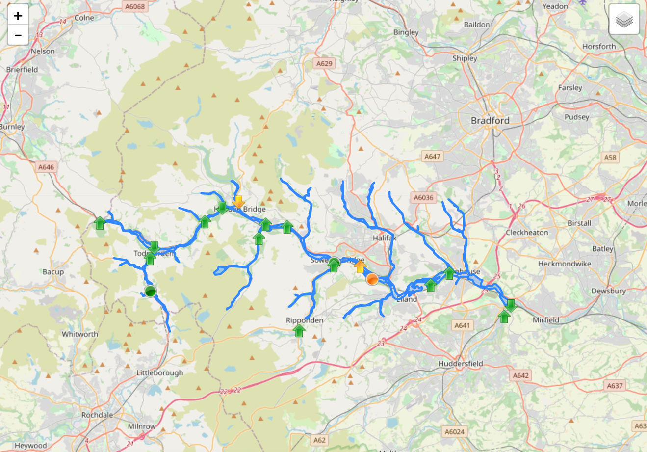
Figure 2. The River Calder and its tributaries within the Calder Valley drainage basin.
(The arrows show if the current water levels are rising or falling. The triangles represent the river level monitoring stations.)
2. What causes flooding in the Calder Valley?
Recent floods have had a significant impact on residents of the Calder Valley in Sowerby Bridge, Hebden Bridge and Mytholmroyd, especially after the Boxing Day floods in 2015 and the flooding caused by Storm Ciara on 2nd February 2020. During the Boxing Day floods, many areas of the Calder Valley saw over 100mm of precipitation in less than 24 hours (Eye on Calderdale, 2020). When Storm Ciara hit the UK there was over 100mm of rainfall in under 18 hours (BBC News, 2020). Prior to these floods, devastation last hit the Calder Valley 79 years ago in 1946.
Calder Valley’s relatively high levels of urbanisation means that the lag time of the River Calder is significantly reduced. More impermeable surfaces mean that the amount of percolation and infiltration within the basin is reduced, which increases surface runoff. In the days leading up to Storm Ciara the peatlands were burnt for grouse shooting, meaning that the upper course of the Calder Valley catchment area saw reduced rates of interception and soils reached saturation point sooner (Monbiot, 2020). Consequently, lag time was reduced contributing to the River Calder becoming bankfull. The river is also full of debris (dredging has been suggested as a possible solution), adding another factor to the flooding in this area (Resident interview, 2020).
3. Impacts of the flooding in the Calder Valley in 2015
The Boxing Day floods caused large amounts of devastation to both businesses and residents resulting in the wettest Boxing Day on record. These floods caused significant damage to over 2,781 homes and 4,416 businesses (Eye on Calderdale, 2020). Many of these businesses were unable to reopen for several months causing economic issues due to an increase in costs and a loss of revenue. Many residents and business owners were unaware of the potential impacts and likelihood of flooding in their area. This was due to a perceived lack of communication from Calderdale Council in the build-up to the event (Business-owner interview, 2020). Most places lacked early warning systems to warn residents of the rapidly increasing river levels due to the prolonged periods of rainfall, which led to many people being unprepared.
These floods had physical and emotional impacts on the people affected due to the immense devastation that was caused to homes and businesses. It impacted the local economy as there were significantly reduced visitor numbers to the area. These losses have been estimated at £47 million as a direct result of this flooding event (Sakai et al, 2016: 3).
4. How effective have the responses to the flooding in 2015 been?
In order to establish the effectiveness of the responses, I interviewed a local business owner in the Calder Valley. The response from Calderdale Council was to set up hubs to help distribute cleaning supplies and groups of volunteers to help with the aftermath. There were also large groups of volunteers that helped with the clean-up by removing debris and damaged goods (Business-owner interview, 2020).
Another response was from a volunteer organisation called ‘Slow the Flow’ (Slow the Flow, 2020). Slow the Flow uses natural flood management, an approach that applies the natural characteristics of the drainage basin to manage the discharge of the river and reduce the impacts and risk of flooding. This flood management approach is sustainable because it involves using natural materials to construct ‘leaky dams’. Their purpose is to increase the lag time of the River Calder and its tributaries therefore slowing the rate of the water flowing downstream reducing the flood risk. However, the main disadvantage of this strategy is that it is quite a small-scale and local approach. Therefore, not very effective at reducing the risk of flooding across the entire drainage basin and river course within Calder Valley. Another natural flood management strategy that was put in place was Treesponsibility planting 10,000 trees within the drainage basin to increase interception rates causing the lag time to increase which reduces flood risk (Pidd, 2020). Furthermore, it increases the amount of root uptake and evapotranspiration allowing the transfer of water from the hydrosphere to the biosphere and atmosphere. Reducing the amount of water stored in the hydrosphere means that the water in the river channel is significantly less.
Academic geographers suggest that the ‘strong sense of community’ in the upper Calder Valley has contributed to the prominence of community-led management attempts in the area demonstrated by Slow the Flow. However, these same researchers have also suggested that although there was a ‘strong initial response’ by the locality after the 2015 floods, this ‘diminished over time due to apathy, “active forgetting” and lack of further exposure’ (Forrest et al., 2019). The ongoing work of Slow the Flow challenges this conclusion and suggests that there has been a sustainable ongoing response from a core group within the local community.
Investment of £30million by Calderdale Council and the Environment Agency to improve the current flood defences (Pidd, 2020) was another response. These improvements included the relocation of a bridge in Mytholmroyd, increasing the height of the current flood walls and widening the river channel. Both relocating the bridge and widening the river channel meant that the volume of the river channel increased. These hard engineering strategies intended to lower the risk of flooding in at-risk areas. However, the improvements to the flood walls in Mytholmroyd were not completed before Storm Ciara hit causing them to be ineffective. Consequently, the impacts of this later flooding event were enhanced due to incomplete flood defences.
5. Impacts of the flooding in the Calder Valley in 2020
When Storm Ciara hit the UK on 2nd February 2020 it flooded 500 properties and 400 businesses (BBC News, 2020). Many of the businesses that were flooded by Storm Ciara were also damaged in the 2015 Boxing Day floods resulting in them being hit again economically because of the extensive damage received. Again, large amounts of damage occurred to properties along this river, many of which still have not fully recovered from this flooding event. Flood insurance was either unaffordable or excluded which has then decreased their ability to recover from this even further. The impacts of Storm Ciara are severe due to the flood defences not being complete before the storm hit the area. In particular, water was able to escape from incomplete sections of the raised walls around Mytholmroyd, causing major flooding to the A646, the main route through the Calder Valley, as well as to nearby homes and businesses. Evidently, the failure to complete the defences in time meant that the area was not adequately protected as well as leaving part of Mytholmroyd particularly vulnerable.
6. How effective has the responses to the flooding in 2020 been?
In researching the effectiveness of the responses to the Calder Valley flooding 2020, I interviewed a resident of Sowerby Bridge who had experienced the flooding. When she was asked about her opinion of the effectiveness of the responses to the flooding, she replied, “The responses were not very effective as there was no contact from Calderdale Council to inform me of the help available after the flood” (Resident interview, 2020). However, one of the responses to this flooding event was that the local community set up flood relief centres which provided hot drinks, cleaning products and help cleaning up the damage. Hebden Bridge had a better organised response to the flooding than Sowerby Bridge which then led to immediate response from people in Hebden Bridge being more effective (Resident interview, 2020). This is further evidence of the importance of local community responses to the management of flooding in this area, though again my interviewee’s comments confirmed the finding of academic geographers that community responses can vary between places, even within the same drainage basin (Forrest et al., 2019). See Figure 3 for summary of quotes.
Another significant management strategy implemented ahead of the 2020 flooding was that the Environment Agency had ensured all reservoirs in the Calder Valley drainage basin were at most 90% full by the end of summer 2019. Consequently, this increased the spare capacity of the reservoirs, enabling them to increase storage during periods of heavy rainfall providing better protection. Furthermore, there is also a flood resilience grant scheme which pays up to £5000 to help homes and businesses to increase their flood defences to increase protection from future floods (Wilcox, 2020).

Figure 3. Quotes from the interviews that I conducted about the impact the flooding had on a local business and a local resident.
Figure 3 shows that people were unaware of the flood risk which highlights that there is a lack of support and information available for both businesses and residents. The locals have a number of different ideas on how to reduce the risk and impact of flooding in this area.
7. Conclusions
Overall, I believe the responses to the floods in 2020 were more effective than the responses to the flooding in 2015. This is due to the responses being more localised for the 2020 flooding event which meant that some areas such as Sowerby Bridge had fewer substantial responses in place in comparison to Hebden Bridge as they had a flood relief centre in place which aided the responses to the event. The impacts of the flooding in 2015 were similar to the impacts of the 2020 flooding event however the impacts of the 2020 flooding were less widespread and long-standing, suggesting these strategies have helped. However, there were still weaknesses with this strategy such as the failure to complete the hard engineering in time which meant that the area wasn’t adequately protected.
Two overall recommendations can be made for future flood management in the area. First, the new hard engineering strategies should be completed as soon as possible, and then studies should be commissioned to confirm their long-term suitability in the face of predicted increases in precipitation levels for the Calder Valley. Secondly, more support should be given to help community-level management strategies become more long-term and sustainable, building on the strong foundations that academic geographers have already identified in the area (Forrest et al., 2019). Hard engineering strategies are the main management strategy being used nationally to manage flooding because of their effectiveness. This highlights the hard engineering strategies within the Calder Valley should be highly effective at protecting the area once they are complete. However, the presence of ongoing natural flood management strategies in the Calder Valley, such as Slow the Flow, which work with both nature and the local community to reduce flood risk, means that further studies should be done to explore the role that such strategies can play in complementing and supporting hard engineering approaches.
8. References
BBC News, 10th February 2020 ‘Storm Ciara Aftermath: Calder Valley assesses flood damage’ https://www.bbc.co.uk/news/uk-england-leeds-51442199 [Accessed 1st July 2020]
Environment Agency (2011) ‘Understanding The Risks, Empowering Communities, Building Resilience’. [online] Available at: https://assets.publishing.service.gov.uk/government/uploads/system/uploads/attachment_data/file/228898/9780108510366.pdf [Accessed 22nd January 2021].
Eye on Calderdale, (2020), ‘History of Flooding in Calderdale, available at https://eyeoncalderdale.com/history-of-flooding-in-calderdale [Accessed 1st July 2020]
Forrest, S., Trell, E-M, and Woltjer, J. (2019), ‘Civil society contributions to local level flood resilience: Before, during and after the 2015 Boxing Day floods in the Upper Calder Valley’, Transactions of the Institute of British Geographers, 44: 422-436
Interview with business owner affected by 2015 floods in Calder Valley (anonymised), conducted on 29th May 2020.
Interview with resident of Sowerby Bridge (anonymised), conducted on 10th June 2020
Monbiot, G., 11th February 2020‘If we want to cut flooding we should stop burning the moorland’, The Guardian https://www.theguardian.com/commentisfree/2020/feb/11/flooding-moorland-river-calder-flooded-peatlands [Accessed 15th January 2021]
Pidd, H., 21st February 2020, ‘Six floods in five years: life in Yorkshire’s Calder Valley’, The Guardian https://www.theguardian.com/environment/2020/feb/21/dams-wellies-and-sleepless-nights-yorkshire-calder-valley-flooding [Accessed 1st July 2020]
Sakai,P., Holdsworth,A.,Curry,S. (2016), Economic Impact Assessment of the Boxing Day Floods (2015) on SME’s in the Borough of Calderdale, University Of Leeds https://www.see.leeds.ac.uk/uploads/media/Economic_Impact_Assessment_of_Boxing_Day_floods.pdf [Accessed 1st July 2020]
Slow the Flow, 2020 National Trust Press Release, http://slowtheflow.net [Accessed 1st July 2020]
Wilcox, S., 17th July 2020, ‘Calderdale Council announces new flood support fund’ , Halifax Courier https://www.halifaxcourier.co.uk/business/calderdale-council-announces-new-flood-support-fund-2917102 [Accessed 19th July 2020]
#Write for Routes
Are you 6th form or undergraduate geographer?
Do you have work that you are proud of and want to share?
Submit your work to our expert team of peer reviewers who will help you take it to the next level.
Related articles
