
By Naomi Louise Gammon, The King’s School
Citation
Gammon, N. L. (2020) Investigating whether carbon storage varies significantly between areas of deciduous woodland on the North East and South West facing slopes of St. Cyres’ Hill, East Devon. Routes 1(2): 226-235.
Abstract
Land in the UK must be used efficiently to reduce net CO2 emissions. Land suitable for afforestation may be sloped, therefore the potential for carbon sequestration may vary with aspect. This investigation analyses the mass of carbon stored on the south west facing and north east facing slopes of St Cyres’ Hill, East Devon (50.81244315, -3.20986175) with the aim of understanding whether aspect significantly affects carbon storage. Tree height and density were used to quantify carbon storage at nine 10x10m sites on each slope. Field research was substantiated by secondary data showing geology, climate and the slope profile, which were found to be controlled across the sites. The Mann-Whitney U test showed that, at p=0.05, there was no significant difference in carbon storage on the north east facing and south west facing slopes. This suggests that any land unsuitable for alternative use should be afforested regardless of aspect.
1. Introduction
Since the Industrial Revolution, the atmospheric concentration of CO2 has increased by approximately 127 parts per million (Lindsey, 2020). This is significant as CO2 increases radiative forcing (EPA, 2016), thus contributing to global warming. The Paris Agreement aims to keep ‘a global temperature rise this century well below 2 degrees Celsius above pre-industrial levels and to pursue efforts to limit the temperature increase…to 1.5 degrees Celsius’ (UNFCCC, 2020). According to the IPCC, global strategies to meet a 1.5oC target ‘predominantly rely on BECCS and afforestation/reforestation’ (Rogelji et al, 2018:121). In response, the Committee on Climate Change suggests that, under a central scenario, 15,000 hectares could be afforested annually in the UK to reduce emissions by 8Mt CO2 in 2050 (Committee on Climate Change, 2016). However, woodlands have a lower economic value than agriculture (Beedell, 2019) and housing developments, so it is not feasible to afforest expansive areas. On Exmoor, for example, afforestation is most likely to occur on sloped, poor quality agricultural land (Stephenson & Butcher, 2010). It is therefore essential that these small areas of land which are unsuitable for housing developments are used efficiently to allow national afforestation targets to be met.
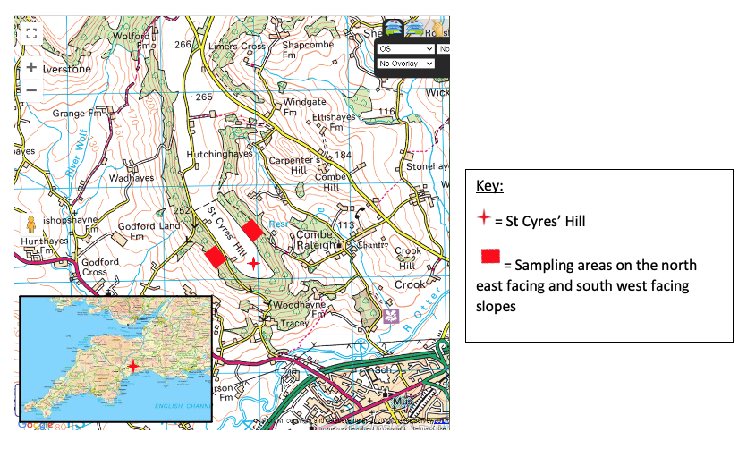
The amount of carbon sequestered by an area of deciduous woodland is affected by the limiting factors for photosynthesis: atmospheric CO2 concentration, temperature, water availability and light intensity (Toole & Toole, 2015). St Cyres’ Hill (shown by Figure 1) was selected to study as both slopes have deciduous woodland and are exposed to similar atmospheric CO2 concentrations and annual rainfall. Therefore, a variation in light intensity and temperature due to aspect could explain any significant difference in carbon storage between the south west and north east facing slopes. It is expected that carbon storage will be greater on the south west facing slope because this will receive more hours of sunlight per day at a higher intensity (Baner, 2020).
This investigation focusses on the potential for carbon sequestration through afforestation and woodland conservation on hillslopes such as St Cyres’ Hill. The topography reflects that of low-value land which Stephenson and Butcher (2010) suggest as possible sites for afforestation. The investigation aims to contribute towards understanding whether carbon storage in deciduous woodland differs between slopes of contrasting aspects, and will be centred on the following research questions: 1) Is there a significant difference between carbon storage on each slope? 2) Are factors other than aspect affecting carbon storage? Question 1 will be answered by estimating the carbon stored at nine 10x10m sites on each slope and testing any difference using the Mann Whitney U test. To address question 2, geology and climate will be investigated. If confounding variables are controlled across the sites, the study could suggest with more certainty whether aspect should be considered when selecting land for afforestation. This builds upon previous research affirming that forestry is a ‘contributor’ to a low-carbon future (Cannell, 1999: 238), and develops knowledge of factors affecting the sizes of carbon sinks.
2. Methods
2.1 Quantifying stored carbon
The identification of tree species was done using the FSC identification key (Oldham & Roberts, 2014) to eliminate the inaccuracies associated with digital identification. Holmes & Welch’s (2018) method was used to calculate carbon storage due to the minimal equipment required. However, it assumes that the tree is growing perpendicular to the ground, that the tree grows roughly in a cone shape and that 50% of the biomass is carbon, therefore may yield slightly inaccurate results (Holmes & Welch, 2018).
This method was used at nine 10x10m sites on each slope to obtain enough data to draw statistically-based conclusions. Sites were selected using systematic sampling through three transects down each slope, which removed bias in selecting sites whilst ensuring that they were evenly distributed across the slopes. Transects were measured using a trundle wheel, therefore the locations of sites may be slightly inaccurate due to uneven terrain. This could be improved by using a GPS.
The Mann Whitney U test was used to test the significance of any variation in carbon storage between the slopes and provide a statistical underpinning to the conclusion. It is more appropriate than the student t-test because it is non-parametric and compares the medians of each dataset, so the conclusion will not be affected by anomalously large or small trees (Harris, 2016). The critical value at p=0.05 was used to follow convention (Dallal, 2016) and showed that, if a significant difference were found, it could be concluded with 95% certainty that results were not due to chance. This was an appropriate accuracy given the underlying uncertainties created by assumptions in the methodology.
Data was tested against the null hypothesis: “There is no significant difference in the mass of carbon stored per 10x10m site on the north east facing and the south west facing slopes of St Cyres’ Hill”.
2.2 Confounding variables
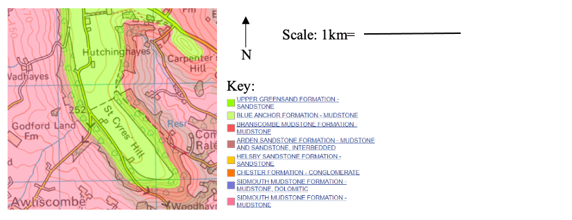
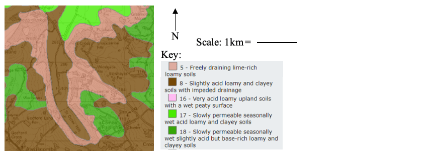
Geology was investigated because it can affect carbon storage by influencing soil properties (Bareja, 2019), so needed to be controlled across the sites to reach a valid conclusion. Where’s the Path (Chadwick, 2019) was used as it showed data from British Geological Survey overlain onto an Ordnance Survey map, so bedrock could be analysed in relation to the areas of woodland. Soil type was taken from MAGiC Map Application (DEFRA, 2005). Air temperature was measured as it is a limiting factor for photosynthesis. This was done with a thermometer (-5-110oC) at site 1 on each slope by taking five readings at one minute intervals to obtain a mode, reducing the impact of any human error. All temperature readings were taken within 30 minutes so were not affected by weather change, but validity could be improved by collecting data over a more extended period. Wind increases transpiration (USGS, 2020), so was investigated using “Windfinder”, as this displays the mean wind direction between 2009 and 2019 using data from the nearest weather station to the sample site. It is limited, however, in not allowing identification of storm winds. A slope profile was drawn to show any variation in gradient which may affect carbon storage. Data to calculate the gradient was obtained by laying out a transect line up the slope perpendicular to the slope contours. Ranging poles were placed at the 0 mark on the tape measure and where the gradient first changed. The distance and angle (obtained using a clinometer) between each ranging pole was obtained, then the first ranging pole was moved to the next location of gradient change and the method was repeated up the slope. Clinometer use is subject to human error so, if the investigation were to be repeated, ranging poles with electronic angle sensors could be used.
3. Results
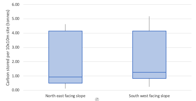
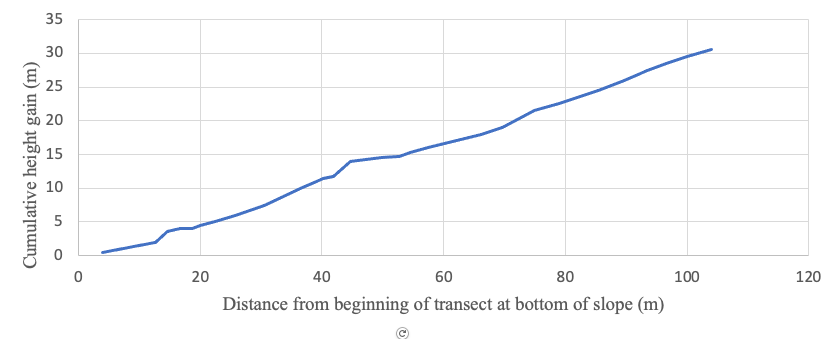
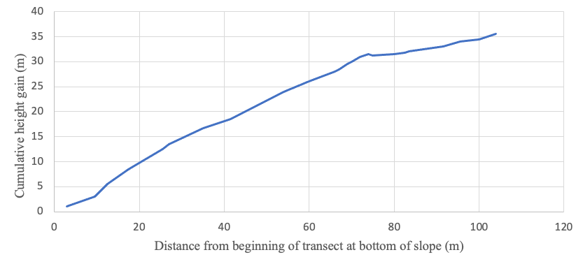
Figure 2 shows that that the mean mass of carbon stored per site was higher the south west facing slope (2.26 tonnes) on than on the north east facing slope (1.59 tonnes). The two sites storing the least carbon (0.12 tonnes and 0.15 tonnes) are on the north east facing slope, whereas the two sites storing the most carbon (5.18 tonnes and 4.93 tonnes) are located on the south west facing slope. There was no significant difference between carbon storage on each slope at p=0.05. Sections 3.2 and 3.3 show that temperature and geology were controlled across the sample sites, and figures 5 and 6 show than the mean gradient on the north east facing slope is 4% shallower.
3.1 Mass of carbon stored at each site
3.2 Climate
Secondary data showed that the modal temperature at both slopes was 25oC and the prevailing wind was from the south west.
3.3 Geology
3.4 Slope profile
4. Discussion
1) Is there a significant difference between carbon storage on each slope?
The Mann-Whitney U test showed that, at p=0.05, there is no significant difference between the mass of carbon stored per site on each slope, meaning that the null hypothesis was accepted. This subverted the expectation that carbon storage would be higher on the south west facing slope, suggesting that effective afforestation can occur on sites of any aspect. Consequently, to meet afforestation targets in the UK, it is advisable to afforest any available land space regardless of aspect. Aspect should not be the determining factor when allocating land for afforestation – from an economic perspective, it is whether the land is able to generate in excess of £6,800 per hectare (the Countryside Stewardship Woodland Creation Grant) (DEFRA, 2018) through alternative use.
Mean tree density was higher on the north east facing slope (8.22/100m2) than on the south west facing slope (6.67/100m2). This reflects how the north east facing slope was characterised by a higher density of smaller trees, meaning that there was a greater range in the mass of carbon stored. These trees stored less carbon per site than the larger, less dense trees on the south west facing slope. Preserving existing woodland could therefore be more important than afforestation in minimising net CO2 emissions, as previously suggested by Thomas et al., (2011).
2) Are factors other than aspect affecting carbon storage?
Secondary data on wind direction complemented the existing theory that the south west facing slope experiences the prevailing wind (Braine, 2010), meaning that increased transpiration may inhibit carbon sequestration. Both sample areas are underlain by upper greensand and have freely-draining loamy soils. The modal temperature on either side of the slope was 25oC; this was unexpected however the trees may have moderated the microclimates (EPA, 2019). The difference in the mean gradient of the slopes and consequent slight moderation of the angle of insolation is likely to have a minimal impact on photosynthesis. Confounding variables are therefore unlikely to affect carbon sequestration, meaning that the results are suitable to infer the importance of considering aspect when selecting sites for afforestation.
The wooded areas of both slopes were largely unmanaged (Furnival, 2019) and had similar abiotic characteristics, although more historical context may be beneficial to the study. However, beech trees were most numerous on the south west facing slope compared to sycamores on the north east facing slope. Consequently, further research is needed to show whether aspect or tree species had the greatest impact on carbon sequestration, although neither significantly affected carbon storage in this study.
5. Conclusions
From this investigation, it can be tentatively concluded that there is no significant difference in carbon storage in areas of deciduous woodland on the north east facing and south west facing slopes of St Cyres’ Hill. This may be because the influence of aspect on light intensity was not great enough to alter the rate of photosynthesis, or because carbon sequestration was limited by another factor such as exposure to prevailing winds. Additionally, the observed variation in tree species also did not cause a significant difference in carbon storage, but may have accentuated any impact of aspect as beech has a higher nominal specific gravity than sycamore (Jenkins et al., 2011). Carbon storage was highest at sites with fewer, larger trees, which emphasises the value of preserving existing, mature areas of woodland as carbon sinks.
The investigation could be extended by exploring whether the mass of carbon stored per site is similar in another area of deciduous woodland in the Blackdown Hills, such as the slopes of Hembury Fort. On a larger scale, the investigation could be repeated across areas of deciduous woodland on south west facing and north east facing slopes across the UK, as increasing the sample size would further reduce the influence of confounding variables to suggest at which aspect carbon storage is typically higher. This could lead to conclusions more applicable to identifying appropriate sites for afforestation across the country.
6. Acknowledgements
Dr C. Hawkins and The King’s School Geography Department for invaluable guidance through the A Level NEA process. Tracey Estate for kindly allowing me to access St Cyres’ Hill during fieldwork.
7. References
Bareja, B. 2019. Topography and soil, biotic factors affecting crop growth, development and productivity. Crops Review. [Online]. Available at: https://www.cropsreview.com/abiotic-factors.html. Accessed: 14 July 2019.
Baner, S. 2020. Factors Influencing Temperature. [Online]. Available at: http://www.yourarticlelibrary.com/geography/climate-geography/factors-influencing-temperature-with-diagram-geography/77664. Accessed: 25 October 2020.
Beedell, J. (Strutt & Parker) 2019. The (positive) value of woodland as part of a mixed estate. [Online]. Available at: https://www.cla.org.uk/sites/default/files/PDF%20Documents/Adding%20Value%20to%20Woodland%20-%20Jason%20Beedell%20Strutt%20&%20Parker.pdf. Accessed: 21 November 2020.
Braine, D. 2010. Devon’s maritime climate explained. [Online]. Available at: http://news.bbc.co.uk/local/devon/hi/people_and_places/nature/newsid_8984000/8984109.stm. Accessed: 9 November 2019.
Cannell, M. 1999. Growing trees to sequester carbon in the UK: answers to some common questions. Forestry: An International Journal of Forestry Research. [E-journal]. 72 (3), pp.237-247. Available at: https://doi.org/10.1093/forestry/72.3.237. Accessed: 12 June 2020.
Chadwick, B. 2019. Where’s the Path. [Online]. Available at: https://wtp2.appspot.com/wheresthepath.htm. Accessed: 11 July 2019.
Committee on Climate Change. 2016. UK climate action following the Paris Agreement. Committee on Climate Change website. [Online]. Available at: https://www.theccc.org.uk/wp-content/uploads/2016/10/UK-climate-action-following-the-Paris-Agreement-Committee-on-Climate-Change-October-2016.pdf. Accessed: 21 July 2019.
Dallal, G. 2012. Why P=0.05?. [Online] Available at: http://www.jerrydallal.com/LHSP/p05.htm. [Accessed: 10 August 2019].
DEFRA. 2005. MAGiC Map Application. [Online]. Available at: https://magic.defra.gov.uk/MagicMap.aspx. Accessed: 13 July 2019.
DEFRA. 2018. Countryside Stewardship Woodland Creation Grant opens for applications. [Online]. Available at: https://www.gov.uk/government/news/countryside-stewardship-woodland-creation-grant-opens-for-applications. Accessed: 30 December 2019.
EPA. 2016. Climate Change Indicators: Climate Forcing. [Online]. Available at: https://www.epa.gov/climate-indicators/climate-change-indicators-climate-forcing). Accessed: 11 June 2020.
EPA. 2019. Using Trees and Vegetation to Reduce Heat Islands. [Online]. Available at: https://www.epa.gov/heat-islands/using-trees-and-vegetation-reduce-heat-islands. Accessed: 12 August 2019.
Furnival, H. 2019. Landowner interview conducted by Gammon, N. July 2019.
Harris, H. 2016. Essential Maths Skills for AS/A-level Geography. Hodder Education. Banbury.
Holmes, D. & Welch. 2017. Carbon cycle fieldwork: Biomass in woodlands. Geography Review. 31 (1), pp.28-31.
Jenkins et al. 2011. Forestry Commission. FC Woodland Carbon Code: Carbon Assessment Protocol, Forestry Commission. [Online]. Available at: https://www.woodlandcarboncode.org.uk/images/PDFs/WCC_CarbonAssessmentProtocol_V2.0_March2018.pdf. Accessed: 21 November 2020.
Lindsey, R. 2020. Climate Change: Atmospheric Carbon Dioxide. [Online]. Available at: https://www.climate.gov/news-features/understanding-climate/climate-change-atmospheric-carbon-dioxide. Accessed: 11 June 2020.
Oldham, J. & Roberts, C. Field Studies Council/Forestry Commission. 2014. The tree name trail. Third Edition. FSC Publications. Telford.
Rogelj, J. et al. 2018. Mitigation Pathways Compatible with 1.5°C in the Context of Sustainable Development. In: Global Warming of 1.5°C. An IPCC Special Report on the impacts of global warming of 1.5°C above pre-industrial levels and related global greenhouse gas emission pathways, in the context of strengthening the global response to the threat of climate change, sustainable development, and efforts to eradicate poverty. IPCC. [Online.] Available at: https://www.ipcc.ch/sr15/. Accessed: 15 November 2019.
Stephenson, W. & Butcher, B. 2010. Exmoor National Park Carbon Neutral Consultation. Exmoor National Park website. [Online]. Available at: https://www.exmoor-nationalpark.gov.uk/__data/assets/pdf_file/0026/221579/EB64-Forum-21-2010-Exmoor-National-Park-Carbon-Neutral-Programme-Consultation.pdf. Accessed: 11 June 2020.
Thomas et al., 2011. Carbon dioxide fluxes over an ancient broadleaved deciduous woodland in southern England. Biogeosciences (8) pp. 1595-1613.
Toole, G. & Toole, S. 2015. AQA Biology. 2edn. Oxford University Press: Glasgow.
UNFCCC. 2019. What is the Paris Agreement? [Online]. Available at: https://unfccc.int/process-and-meetings/the-paris-agreement/what-is-the-paris-agreement. Accessed: 15 November 2019.
USGS. 2020. Evapotranspiration and the Water Cycle. [Online]. Available at: https://www.usgs.gov/special-topic/water-science-school/science/evapotranspiration-and-water-cycle?qt-science_center_objects=0#qt-science_center_objects. Accessed: 24 October 2020.
Windfinder. 2019. Dunkeswell Aerodrome. [Online]. Available at: https://www.windfinder.com/windstatistics/dunkeswell_aerodrome. Accessed: 12 August 2019.
8. Notes on figures
- The location of St Cyres’ Hill in the south west of the UK (50.81244315, -3.20986175). Adapted from Ordnance Survey 2019 © Crown Copyright and database rights. St Cyres’ Hill (314756, 102398). Accessed through: Chadwick, B. 2019. Where’s the Path 3. [Online.] Available at: https://wtp2.appspot.com/wheresthepath.htm. Accessed: 15 November 2020. OnTheWorldMap. 2020. Map of South West England. [Online]. Available at: http://ontheworldmap.com/uk/england/map-of-south-west-england.html. Accessed: 15 November 2020.
- A box plot to show the distribution of carbon storage at sites on the north east and south west facing slopes of St Cyres’ Hill (50.81244315, -3.20986175), July 2019. Gammon, N. 2020.
- A map to show bedrock at St Cyres’ Hill (50.813148, -3.214618). Map: Ordnance Survey 2019 © Crown Copyright and database rights. St Cyres’ Hill (314756, 102398). Data layer: bedrock, reproduced by WTP3 with permission of British Geological Survey © NERC. Accessed through: Chadwick, B. 2019. Where’s the Path 3. [Online]. Available at: https://wtp2.appspot.com/wheresthepath.htm. Accessed: 11 July 2019. Key: adapted from British Geological Survey. 2019. [Online]. Available at: http://mapapps.bgs.ac.uk/geologyofbritain/home.html. Accessed: 11 July 2019.
- A map to show the soil type at St Cyres’ Hill (50.813148, -3.214618). DEFRA. 2005. MAGiC Map Application. [Online]. St Cyres’ Hill (314756, 102398). Data layer: Soilscape (England), National Soil Resources Institute. Available at: https://magic.defra.gov.uk/MagicMap.aspx. Accessed: 13 July 2019.
- A profile of the north east facing slope of St Cyres’ Hill (50.813148, -3.214618). Gammon, N. 2019.
- A profile of the south west facing slope of St Cyres’ Hill (50.813148, -3.214618). Gammon, N. 2019.
#Write for Routes
Are you 6th form or undergraduate geographer?
Do you have work that you are proud of and want to share?
Submit your work to our expert team of peer reviewers who will help you take it to the next level.
Related articles
