
By Lily Duffy, Durham University
Citation
Duffy, L. (2020) Where are the silt layers in the Albufeira Lagoon (Portugal) sourced from? Routes 1(1): 109–119.
Abstract
Tracing the sedimentary evolution of Portuguese lagoons throughout the Holocene is essential to an understanding of the impacts of sea-level rise and human activity on coastal systems in Portugal. Sedimentological analysis of cores recovered at the Albufeira Lagoon, western Portugal, was carried out in order to help identify any silt layers. The slope of the silt layers was reproduced with the aim of determining where the material is sourced from. Whilst a downward slope in a landward direction implies a marine origin, this study found a downward slope in a seaward direction indicative of terrestrial inputs. The study demonstrates that the lagoon evolved as a weakly brackish environment with fluvial inputs, although infrequent marine incursions disrupt this pattern. By determining the source of silt layers in the Albufeira Lagoon, this study contributes to an understanding of modern lagoon processes and shows how current environments provide insight into the past.
1. Introduction
Coastal lagoons mark the boundary between land and sea (Adomat, 2016). They are complex systems formed where valley mouths or basins drowned by Holocene transgression- which reached its maximum at ~5000 Before Present (BP)- have become enclosed by sand barriers (Ferreira et al., 2009; Freitas et al., 2003). The evolution of these lagoons is primarily controlled by local factors such as sediment availability, local geomorphology, wave energy and land management (Adomat, 2016; Cooper, 1995). Covering 13% of the world’s coastlines (Guevara et al., 2019), coastal lagoons are among the most highly productive but vulnerable ecosystems on Earth (Madricardo et al., 2019). Many are sensitive to the impacts of sea-level rise and increasing human disturbance (Cooper, 1995). Human intervention modifies lagoon-ocean water exchanges, particularly through the artificial opening of inlets, which deliver sediment from the coast into the lagoon (Oliveira et al., 2006). Understanding the coastal response to local forcing is of paramount importance when tracing their development (Devoy et al., 1996).
Sediment coring has been used in numerous lagoonal studies to investigate Holocene evolution (Adomat, 2016; Haghani et al., 2006), although the stratigraphies of many coastal environments in Portugal remain unexamined (Devoy et al., 1996). Most Portuguese coastal lagoons developed after 4000-5000 BP and are controlled locally (Bao et al., 1999), but the external influence of extreme sea level events is not well understood due to a lack of observational data (Oppenheimer et al., 2019). This study determines the sedimentological characteristics of the materials deposited during the Holocene in the Albufeira Lagoon, Portugal. By looking at the sedimentological composition of sediment layers and their relationship with elevation, the source of the samples can be inferred based on the direction that they slope (Leorri et al., 2012). The two aims of this study are: i) to characterise past and present environmental conditions by using the Troels-Smith scheme to classify sediments in the Albufeira Lagoon; and ii) to determine whether sediments in the Albufeira Lagoon are marine or terrestrial in their origin by tracing the silt layers across the cores. This can contribute to an understanding of how contemporary processes influence lagoonal sedimentation.
2. Methodology
2.1 Study Site
The Albufeira Lagoon (Figure 1) is located on the west coast of Portugal, 20 kilometres (km) south of Lisbon. It has a maximum depth, width and length of 15 metres (m), 625 m and 3.5 km (Alday et al., 2013). The agricultural land surrounding the study site and the release of urban effluents into the lagoon influences the water level and quality. This has resulted in the artificial breaching of the sand barrier that separates the lagoon from the Atlantic Ocean (Alday et al., 2013). At times, this stretch of the coast experiences violent storms (Bao et al., 1999), and the rate of sea level rise has increased to +1.5 mm/year since the nineteenth century as a result of climate change (Leorri et al., 2012).
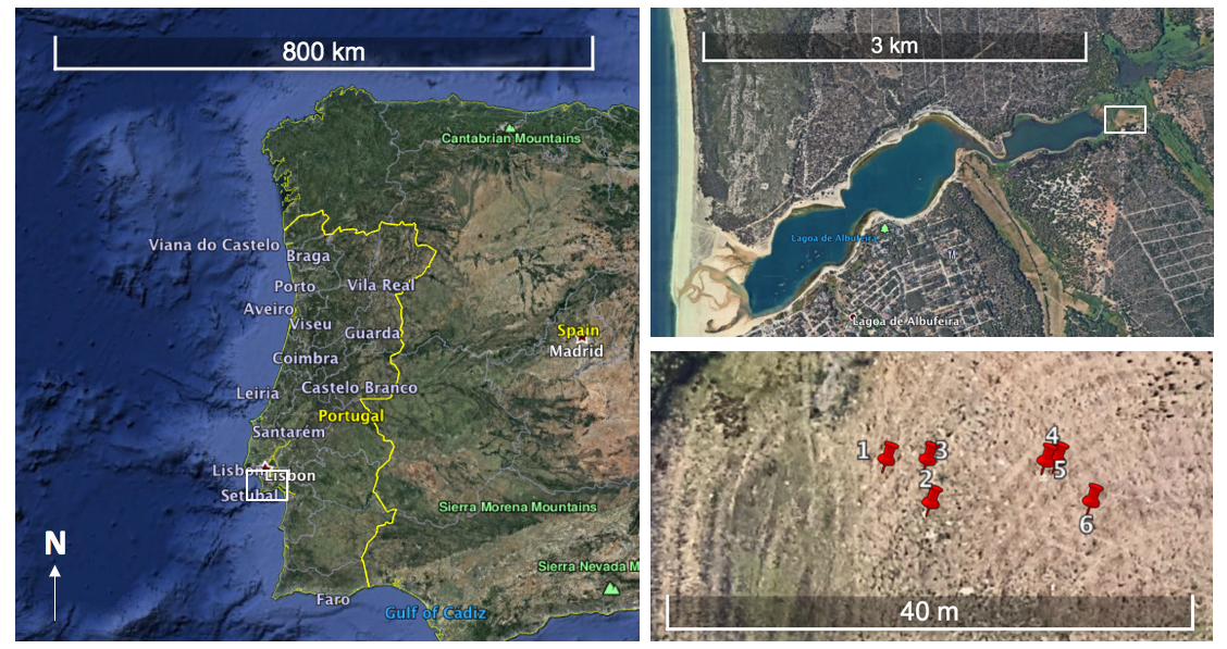
Figure 1. A location map showing the position of the studied cores, taken from Google Earth. Each image zooms further into the site.
2.2 Methods and Materials
Using a gouge coring set, cores 3-5 m in depth were taken approximately 2 m apart in a west to east direction. The Global Positioning System (GPS) coordinates of the cores were recorded, and sediments were classified using the Troels-Smith scheme. The Troels-Smith classification helps to identify unconsolidated sediment in core samples and records the physical characteristics of sediment layers. Starting at the top of the core, the upper and lower boundaries of each stratigraphic unit were identified. The components of the sediment layer were recorded on a 4-point scale where 1 is 25% and 4 is 100% of the layer. So, if sand (Ga) made up 75% of the stratigraphic unit it was given a 3, and if silt (Ag) made up the remaining 25% it was given a 1. The Troels-Smith code for the components of this unit would therefore be Ga3, Ag1. As such, silt layers can be identified. The physical properties of the sediment were described based on its darkness (nig), stratification (strf), dryness (sicc), elasticity (elas) and sharpness of the boundary with the layer immediately above (ls). This study also determined the elevation of the core tops using levelling equipment, and a field sketch map identifying vegetation and different types of sediment was produced. The core data was converted to an excel spreadsheet, and the depth of each sediment layer relative to metres above mean sea level (a.m.s.l) was calculated by subtracting the depth of the recorded sedimentary unit from the levelled core top height. The depth of the different sediment layers within each core was plotted against distance, and sediment profiles were drawn between the plotted levels. The sketch map was drawn to scale using Google Earth and Photoshop, and annotated with the observations made in Portugal.
3. Results
For most of its length the Albufeira Lagoon is stable with a height of up to 1.3 m above mean sea-level (Table 1). The height of the cores above sea level increases in a west to east direction (Figure 2). Core 1 (C1) is the deepest of the cores, ranging from -4.07 to 0.93 m. There are two silt layers present: one between -3.07 and -2.59 m, and a smaller one between -1.4 and -1.21 m. The sand layers found in this core are darker and more saturated at its base. There are no silt layers present in C2, which spans -3.05 to 0.95 m. Instead, it consists of a 0.51 m clay layer and a 3.49 m sand layer, the largest sand layer of any core, that transitions from grey to yellow in colour as it reaches the surface. C3 is composed of a silt layer (-2.48 to -2.23 m), separated by clay and sand layers. There is also a mud layer between 0.22 and 0.39 m, making it distinct from the other cores (in this investigation, mud is interpreted as soil, clay or silt mixed with water). C4 consists of a silt layer (-2.37 to -2.02 m), surrounded by sand and clay layers. The largest silt layer of any core can be found at the base of C5, between -2.61 and -1.96 m. This is overlaid by sand layers and an almost indistinguishable clay layer. There are two silt layers in C6: one between -2.37 and -2.24 m and another between -1.09 and -0.97 m, separated by several clay and sand layers. The top 1 m of C5 and C6 is fine grained sand.
Table 1. Summary of the data obtained from the cores
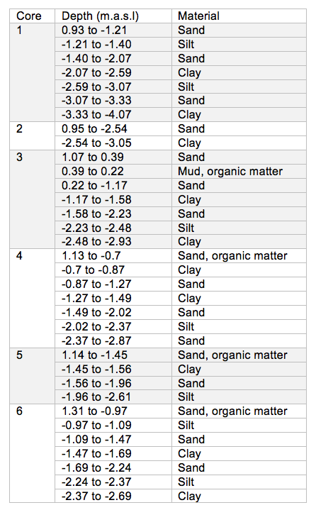
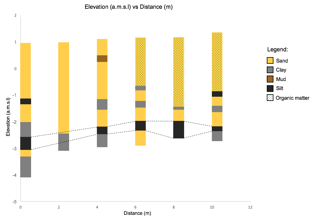
Figure 2. A graph to show the relationship between elevation (a.m.s.l) and distance (m). The dashed lines highlight the slope of the bottom silt layer.
The general trend of the cores is a gentle inland gradient of the silt layers (Figure 2). This gradient is most evident from C1-4, but becomes less evident between C4-6. For C4-6, organic matter is only present in the top sand layer, and does not continue past the clay or silt layers. Saturated silt and sand can be found to the west of the cores, along with some organic matter and marine shells (Figure 3). Highly elevated land can be found to the north of the site.
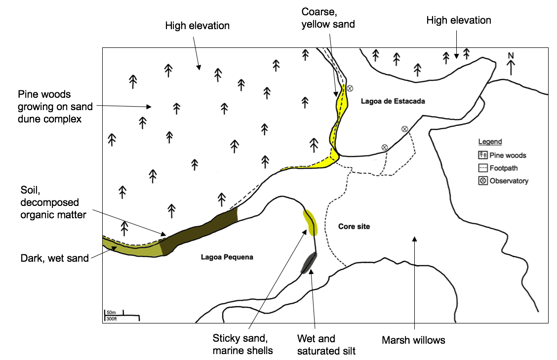
Figure 3. A sketch map of the Albufeira Lagoon, identifying the main vegetation and sediment types.
4. Discussion
4.1. Interpretation of Environment
At the Albufeira Lagoon, there is a slight downward slope of silt layers in a seawards direction, suggesting that sediment comes downstream from the river. Kjerfve and Magill (1989) determined similar findings in that the dominant source of material into lagoons comes from rivers and streams. As the field site is surrounded by highly elevated land, sediment may be brought into the landward side of the lagoon by rivers draining these uplands (Figure 3) (Davidson-Arnott, 2010). Since the grounds of this high elevation are largely sandy in nature, the silt must originate further upstream than the immediate hillslope. If this is not the case, it is likely that the cores would consist solely of sand. However, Bao et al. (1999) highlight that the sedimentology of Portuguese lagoons displays a variation of facies, indicating changing sediment sources. Likewise, Kjerfve and Magill (1989) suggest that it is the combined action of marine and fluvial processes that transport sediment into lagoons, rather than one single source.
Whilst other works have suggested the sediment input is ambiguous, the results presented in this study are indicative of material sourced from a fluvial origin. This is supported by Alday et al. (2013), who show that freshwater conditions have been dominant at the lagoon over the last 2.5 thousand years (ka), occasionally disrupted by barrier breaching. Foraminiferal assemblages (a proxy for environmental change) indicate a slightly brackish environment, although the lagoon remains largely untouched by marine waters (Alday et al., 2013). Likewise, at the Santo André Lagoon- also on the western Portuguese coast- Freitas et al. (2003) found that the pre-Holocene section of their core is characterised by freshwater and terrestrial sediment produced from erosion in the surrounding watershed. The upper units of their core also appear to have been filled by fluvial processes (Freitas et al., 2003). Thus, this supports that lagoons on the western coast have evolved into fluviatile environments.
It is widely acknowledged that silt layers are indicative of a low-energy environment, whilst sand is deposited when there is sufficient wave-energy (Moreira, 2012). As sand deposits dominate the top few metres of each core, separated by layers of fine material, it points to the sedimentation of alternating high and low energy (Freitas et al., 2003). Cores obtained by Freitas et al. (2002) at the same study site also find sand in the top 0.5 and 2m, interpreted as the top of a fluviatile deposit. However, these sediment layers may also have been produced by a large-scale overwash event caused by a late-Holocene tsunami (Switzer and Jones, 2008), or by a storm event (Oertel, 2005). Indeed, Bao et al. (1999) propose that the lagoon occasionally experiences violent storms. Thus, sediment may have come from marine sources. In the future, climate change may enhance the wind and wave energy reaching the coast, changing the composition of the lagoon (Gonzalez-Villanueva et al., 2015).
Plant and shell remains were found at the lagoon, suggestive of a marine environment (Figure 2 and 3) (Cooper, 1995). This is synonymous with the study by Freitas et al. (2003), which found numerous plant remains in the top metre of the core. However, others have stressed that an increase in organic matter is a result of eutrophication, caused by run-off from the land (Gonzalez-Villanueva et al., 2009). Similarly, the Troels-Smith analysis of the cores shows that the top 1m of C5 and C6 is fine sand, unlike the coarse sand found in other cores. As landward fining is typical of a marine origin (Adomat, 2016), it does not support that sediment came from fluvial sources.
4.2. Limitations and Recommendations
Gouge augers are the most commonly used method of retrieving coastal stratigraphic data, and can provide an insight into the impacts of the Holocene transgression (Davidson-Arnott, 2010). However, whilst gouge augers are easily transportable and were therefore deemed suitable for this investigation, only a small surface area is obtained for classification and thus repeated samples are necessary (Simmons et al., 2020). Due to time restrictions, however, this was not possible, and so the sediment retrieved from the cores may not have been an accurate representation of the larger lagoon area. Moreover, the sediment in the open chamber may have been disturbed during recovery (Andrade et al., 2004), and there could be errors in the depth measurements as a result of non-vertical coring or rod bending (Long et al., 1999). In future investigations, a Russian peat corer could be used instead, minimising sediment contamination (Frew, 2014). This may be advanced by means of seismic profiling and ground-penetrating radar (Davidson-Arnott, 2010). There may also have been inaccuracies with the GPS locations (±24 feet) and levelling equipment (Lyon et al., 2018). This is likely to explain why Figure 1 shows the cores arranged in a cluster despite them being an equal distance apart. Moreover, the Troels-Smith classification uses terms which are too generic and may overlap (Long et al., 1999), and it relies on the field descriptions of extruded cores (Schnurrenberger et al., 2003). Therefore, in future investigations this classification scheme may be abandoned in favour of the terminology devised by Folk (1954) for mixtures of gravel, sand, silt, and clay.
In order to provide a better insight into where sediment is sourced from, many studies have analysed the pollen and diatom assemblages of samples taken from cores (Bao et al., 1999). Diatoms are particularly sensitive to changes in salinity and tropic conditions (Anderson and Vos, 1992), and can therefore be used to indicate changes in sea level and reconstruct past climates (Granja et al., 2010). For example, diatom analysis obtained from a core at Lagoa Pequena suggests that it can be characterised as a more tidally influenced environment (Bao et al., 1999). This contrasts with this investigation, which suggests that sediment originated downstream from the river. Coccoliths can also act as a proxy for the measure of marine influence on lagoon deposits (Cearreta et al., 2003). Thus, future investigations should include diatom or coccolith analyses to determine where sediment is sourced from.
5. Conclusion
This study focuses on the sedimentology of Holocene deposits at the Albufeira Lagoon. By examining the trends in the core data, it is evident that the origins of the silt layers are more complex than initially assumed. The results presented based on the sedimentological characteristics of the lagoon suggest fluvial sources dominate as the origin of material, yet material can become incorporated during marine incursions. However, this is not well documented and there may be other processes involved. The study is limited in scope and it is not yet known how changes in sea-level or barrier breaching may influence the long-term stability of the lagoon. More research is required into diatom assemblages because of their usefulness as indicators of past environmental conditions.
6. References
Adomat, F. (2016). Holocene evolution of coastal lagoon environments in Belize, Central America: Analysis of stratigraphic patterns, mollusk shell concentrations and storm deposition (Dissertation). Goethe University, Frankfurt.
Alday, M., Cearreta, A., Freitas, M. C., Andrade, C. (2013). Modern and late Holocene foraminiferal record of restricted environmental conditions in the Albufeira Lagoon, SW Portugal. Geologica Acta. 11(1), p75-84.
Anderson, N. and Vos, P. (1992). Learning from the past: Diatoms as palaeoecological indicators of changes in marine environments. Netherlands Journal of Aquatic Ecology, 26(1), p19-30.
Andrade, C., Freitas, M. C., Moreno, J., Craveiro, S. C. (2004). Stratigraphical evidence of Late Holocene barrier breaching and extreme storms in lagoonal sediments of Ria Formosa, Algarve, Portugal. Marine Geology, 210, p339-362.
Bao, R., Freitas, M. C., Andrade, C. (1999). Separating eustatic from local environmental effects: a late-Holocene record of coastal change in Albufeira Lagoon, Portugal. The Holocene, 9(3), p341-352.
Cearreta, A., Cachão, M., Cabral, M., Bao, R., Ramalho, M. (2003). Lateglacial and Holocene environmental changes in Portuguese coastal lagoons 2: microfossil multiproxy reconstruction of the Santo André coastal area. The Holocene, 13(3), p447-458.
Cooper, J. A. G. (1995). Lagoons and microtidal coasts. In: Carter, R. W. G. and Woodroffe, C. D. Coastal Evolution: Late Quaternary Shoreline Morphodynamics. Cambridge: Cambridge University Press. p219-266.
Davidson-Arnott, R. (2010). Introduction to coastal processes and geomorphology. Cambridge: Cambridge University Press. p280-319.
Devoy, R. J. N., Delaney, C., Carter, R. W. G., Jennings, S. C. (1996). Coastal Stratigraphies as Indicators of Environmental Changes upon European Atlantic Coasts in the Late Holocene. Journal of Coastal Research, 12(3), p564-588.
Ferreira, T., Ramos, R., Freitas, M. C., Andrade, C. (2009). Morphological Evolution of the Óbidos Lagoon (Western Coast of Portugal) Since the Holocene Transgressive Maximum. Journal of Coastal Research, SI(56), p612-616.
Folk, R. L. (1954). The distinction between grain size and mineral composition in sedimentary rock nomenclature. The Journal of Geology, 62(4), p344-359.
Freitas, M. C., Andrade, C., Cruces, A. (2002). The geological record of environmental changes in southwestern Portuguese coastal lagoons since the Lateglacial. Quaternary International, 93-94, p161-170.
Freitas, M. C., Andrade, C., Rocha, F., Tassinari, C., Munhá, J., Cruces, A., Vidinha, J., Silva, C. M. (2003). Lateglacial and Holocene environmental changes in Portuguese coastal lagoons 1: the sedimentological and geochemical records of the Santo André coastal area, The Holocene, 13(3), p433-446.
Frew, C. (2014). 4.1.1 Coring Methods. In: Cook, S. J., Clarke, L. E., Nield, J. M. Geomorphological Techniques (Online edition). London: British Society for Geomorphology. p1-10.
Gonzalez-Villanueva, R., Pérez-Arlucea, M., Alejo, I., Goble, R. (2009). Climatic-related factors controlling the sedimentary architecture of a Barrier- Lagoon complex in the context of the Holocene transgression. Journal of Coastal Research, SI 56, p627-631.
Gonzalez-Villanueva, R., Pérez-Arlucea, M., Costas, S., Bao, R., Otero, X., Goble, R. (2015). 8000 years of environmental evolution of barrier–lagoon systems emplaced in coastal embayments (NW Iberia). The Holocene, 25(11), p1786-1801.
Granja, H., Rocha, F., Matias, M., Moura, R., Caldas, F., Marques, J., Tareco, H. (2010). Lagoa da Apúlia: A residual lagoon from the Late Holocene (NW coastal zone of Portugal). Quaternary International, 221(1-2), p46-57.
Guevara, J. S., Silva, R., Lithgow, D. (2019). Assessment of Sedimentation in a Coastal Lagoon: Chantuto-Panzacola, Mexico. Journal of Coastal Research, 92, p145-156.
Haghani, S., Leroy, S., Wesselingh, F., Rose, N. (2016). Rapid evolution of coastal lagoons in response to human interference under rapid sea level change: A south Caspian Sea case study. Quaternary International, 408, p93-112.
Kjerfve, B. and Magill, K. E. (1989). Geographic and hydrodynamic characteristics of shallow coastal lagoons. Marine Geology, 88(3-4), p187-199.
Leorri, E., Fatela, F., Drago, T., Bradley, S., Moreno, J., Cearreta, A. (2012). Lateglacial and Holocene coastal evolution in the Minho estuary (N Portugal): Implications for understanding sea-level changes in Atlantic Iberia. The Holocene, 23(3), p353-363.
Long, A. J., Innes, J. B., Shannon, I., Tooley, M. J. (1999). Coastal stratigraphy: a case study from Johns River, Washington, USA. In: Jones, A. P., Tucker, M. E., Hart, J. K. The Description & Analysis of Quaternary Stratigraphic Field Sections. London: Quaternary Research Association. p267-286.
Lyon, T. J., Filmer, M. S., Featherstone, W. E. (2018). On the Use of Repeat Leveling for the Determination of Vertical Land Motion: Artifacts, Aliasing, and Extrapolation Errors. Journal of Geophysical Research: Solid Earth, 123, p7021-7039.
Madricardo, F., Foglini, F., Campiani, E., Grande, V., Catenacci, E., Petrizzo, A., Kruss, A., Toso, C., Trincardi, F. (2019). Assessing the human footprint on the sea-floor of coastal systems: the case of the Venice Lagoon, Italy. Scientific Reports, 9(1), p1-13.
Moreira, S. (2012). Palaeoenvironmental reconstruction of Pederneira Lagoon (Western Portugal). Quaternary International, 279-280, p334.
Oertel, G. F. (2005). Coastal Lakes and Lagoons. In: Schwartz, M. L. Encyclopedia of Coastal Science. Dordrecht: Springer. p263-266.
Oliveira, A., Fortunato, A., Rego, J. (2006). Effect of morphological changes on the hydrodynamics and flushing properties of the Óbidos lagoon (Portugal). Continental Shelf Research, 26(8), p917-942.
Oppenheimer, M., Glavovic, B. C., Hinkel, J., van de Wal, R., Magnan, A. K., Abd-Elgawad, A., Cai, R., Cifuentes-Jara, M., DeConto, R. M., Ghosh, T., Hay, J., Isla, F., Marzeion, B., Meyssignac, B., Sebesvari, Z. (2019). Sea Level Rise and Implications for Low-Lying Islands, Coasts and Communities. In: Pörtner, H., Roberts, D. C., Masson-Delmotte, V., Zhai, P., Tignor, M., Poloczanska, E., Mintenbeck, K., Alegría, A., Nicolai, M., Okem, A., Petzold, J., Rama, B., Weyer, N. M. IPCC Special Report on the Ocean and Cryosphere in a Changing Climate. p321-p445.
Schnurrenberger, D., Russell, J., Kelts, K. (2003). Classification of lacustrine sediments based on sedimentary components. Journal of Paleolimnology, 29, p141-154.
Simmons, K., Deatrick, J., Ackerman, L., Lewis, B. (2020). Sediment sampling. Athens, GA: U.S. Environmental Protection Agency. p1-17. Available: https://www.epa.gov/sites/production/files/2015-06/documents/Sediment-Sampling.pdf. Last accessed 19th April 2020.
Switzer, A. D. and Jones, B. G. (2008). Large-scale washover sedimentation in a freshwater lagoon from the southeast Australian coast: sea-level change, tsunami or exceptionally large storm?. The Holocene, 18(5), p787-803.
#Write for Routes
Are you 6th form or undergraduate geographer?
Do you have work that you are proud of and want to share?
Submit your work to our expert team of peer reviewers who will help you take it to the next level.
Related articles
