
Volume 5 Issue 1
By Ben Millward-Sadler, University of Cambridge
Citation
Millward-Sadler, B. 2026. Multihazard Risk Mitigation Strategy for Goma, Democratic Republic of the Congo. Routes, 5(1): 33-66.
Abstract
Goma, a city in the North Kivu province of the Democratic Republic of the Congo, is situated in a complex multihazard environment. Volcanic and limnic eruptions, CO2 emissions, tsunamis, flooding, and landslides all threaten the city and its inhabitants, the risks from which are compounded by the region’s political instability and socioeconomic vulnerability. This report models the risks posed by each of these hazards using both quantitative and qualitative assessments. Spatial patterns of risk and vulnerability across Goma and the surrounding area were analysed using the Pressure and Release framework originally proposed by Wisner et al. (2003). The region’s key hazards include effusive volcanic and limnic eruptions (stemming from the nearby volcano of Mt. Nyiragongo), CO2 emissions (locally Mazuku), tsunamis, flooding, earthquakes, and landslides. The distinct spatial inequalities within the city and its wider catchment make hazard planning and mitigation measures more difficult to design and implement. Due to the complex nature of this region’s hazards, combined with these inequalities, this report advocates for a focus on resilience building and increasing community preparedness, in addition to efforts to directly reduce the impacts of these hazards. Indeed, in the context of Goma’s complex multi-hazard environment, this report advocates for a similarly interconnected multi-response plan to mitigate against them.
1. Introduction
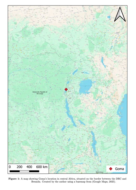
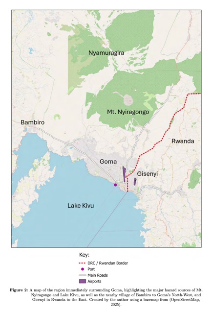
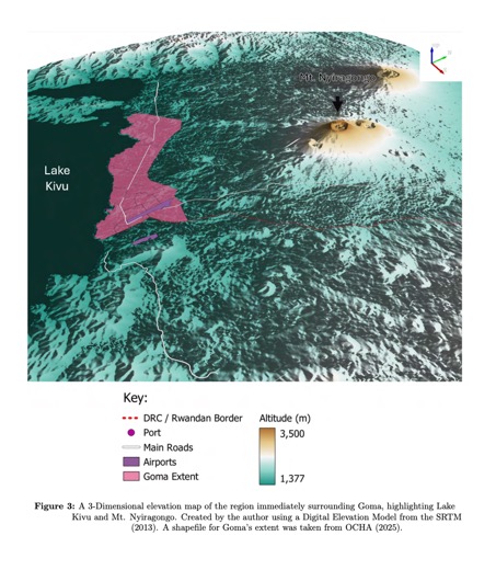
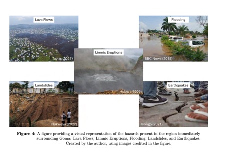
The 2015 Sendai Framework proposed four pillars of improving disaster risk reduction, notably focusing on strengthening governance and increasing resilience (United Nations, 2015). This report will build upon this framework, applying its principles to the city of Goma in the Democratic Republic of the Congo (hereafter DRC). As shown in Figures 1, 2 & 3, the city’s location in close proximity to the volcano Mt. Nyiragongo to the North and Lake Kivu to the South situates Goma at the confluence of two major hazard sources (Michellier et al., 2020). Hazards include effusive volcanic and limnic eruptions, CO2 emissions (locally Mazuku), tsunamis, flooding, earthquakes, and landslides; visual representations of which are shown in Figure 4.
Goma’s population of approximately 2 million makes it one of the most densely populated areas in the world that is routinely exposed to volcanic hazards (Kakozi et al., 2023). Goma also has a precarious sociopolitical situation: civil unrest, stemming from rebel groups, has led to widespread violence, causing a ‘major humanitarian crisis’, with shortages of food, clean water, and medicine (CAFOD, 2025, :np). This has resulted in prominent refugee camps, characterised by overcrowding and poorly-constructed buildings, often located in locations that are particularly vulnerable to hazards (Balagizi et al., 2018). Furthermore, much of Goma’s population lives below the poverty line: 90% of households receive <US$2 daily (Nzanzu et al., 2021; World Bank, 2022). Weak governance and conflict in the area have severe implications for the population’s capacity to cope with natural hazards (Wisner, 2017). Tensions with Rwanda have historically led to influxes of refugees across the border, most notably in 1994 (Pierret, 2024). These tensions have been exacerbated in recent years amid reports that Rwanda is funding rebel activity in the country (Zane, 2025).
The combination of these socioeconomic and political factors, in addition to the broad threats posed by the intersection of the region’s natural hazards, makes Goma a unique case study for multihazard management strategies. Whilst much research has either assessed the hazards in the area (for example Balagizi et al. (2018)), or proposed and evaluated existing mitigation schemes (for example Mafuko- Nyandwi et al. (2024)), there is little literature combining the two. This article aims to address this gap by creating a holistic and comprehensive hazard management and mitigation strategy for the wider Goma region, assessing the risks posed by the region’s varied hazards by integrating remotely-sensed primary data with secondary data from pre-existing studies. This enables the widespread analysis of hazards such as landslide risk, limnic eruptions, and tsunamis using remotely sensed data, and the assessment of hazards such as effusive volcanic eruptions, Mazuku, and earthquakes using the data and assessments of pre-existing literature. Following these assessments of hazard risk, this article formulates realistic policy recommendations for the addressing of these hazards.
2. Methods
The wide variety of hazards present around Goma presents challenges to their effective modelling and mapping. Each individual hazard requires a unique methodology to appropriately categorise the risks it creates; volcanic hazards were assessed using the digitisation of past eruption maps, in particular highlighting volcanic vents, fissures, and lava flows. Landslide hazards were assessed by creating an empirical model of landslide risk, accounting for factors such as slope, soil bulk density, vegetation density and soil moisture.
2.1. Lava Flow, Vent and Fissure Digitisation
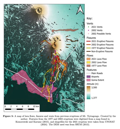
Maps of past lava flows, vents, and fissures in 1977 and 2002 (Komorowski and Karume, 2015) were digitised using QGIS, then integrated into a pre-digitised lava flow map of the 2021 eruption taken from UNOSAT (2024). Whilst this article does not attempt to quantitatively model potential future vent or fissure locations, it does offer insight into past eruption patterns and severity, which are still useful in informing future management practices. Given Mt. Nyiragongo’s effusive nature, and the lack of summit glaciers, volcanic hazards such as tephra, ash fall or lahars are unlikely or impossible in this region, meaning they are not assessed here.
2.2. Landslide Risk Modelling
This method created a quantitative map of landslide risk at a resolution of 30m2 , that assigned areas a level of risk between zero and one, with higher values indicating a greater risk of slope failure. This model utilised elevation data from SRTM (2013), as well as remotely-sensed satellite data from European Space Agency (ESA) (2025) to calculate vegetation indices. Normalised Difference Vegetation Index (NDVI) is a vegetation index which measures the ’greenness’ of vegetation by calculating the difference in reflectance of the red and near infrared (NIR) bands of satellite imagery (Rouse et al., 1973). Chlorophyll effectively absorbs red light, whilst healthy leaves tend to reflect light in the NIR spectrum due to their mesophyll cavities, hence making the difference between red and NIR reflectance a good indicator of leaf health.. Normalised Difference Moisture Index (NDMI), by contrast, infers leaf water content by calculating the difference between the NIR and short wave infrared (SWIR) spectra (Gao, 1996). Leaves with high water concentrations effectively absorb light in the SWIR spectrum, enabling an inference of the moisture content of the leaf (Gao, 1996). NDMI, in the absence of highresolution precipitation or soil moisture data (as is the case for the Goma region), is used here as a proxy for soil moisture.
Slope was calculated using the integrated Earth Engine function ee.Terrain.slope(), the documentation for which can be found at Google Earth Engine (n.d.).
This method was adapted from Shah (2021), and limited by data scarcity for historical landslides in Goma, making self-determined weightings, and indeed weightings specific to Goma, impossible. Instead, weights were adapted from Getachew and Meten (2021):
- Slope: 50%
- Soil bulk density: 30%
- Vegetation density: 10%
- Soil moisture: 10%
Areas with a slope of less than 5◦ were excluded (landslides cannot occur in areas with very small or non-existent slope values), resulting in the following overall equation being used:
LR = (nSlope>5◦ × 0.5) + (nSBD × 0.3) + (iNDV I × 0.1) + (NDMI × 0.1)
Where LR = landslide risk, nSlope = normalised slope values, nSBD = normalised soil bulk density, and iNDV I = inverted NDVI – increased vegetation coverage reduces landslide risk; roots increase soil cohesion and shear strength (Li and Duan, 2024).
2.3. Limnic Eruption Modelling
The potential extent of a limnic eruption from Lake Kivu was determined by creating a flat plane at a known elevation above the lake in QGIS, using a DEM provided by SRTM (2013). This process was repeated at differing heights until the volume enclosed between the flat plane and the lake/ground surface equalled Balagizi et al. (2018)’s estimate that there is 300 km3 of dissolved CO2 in Lake Kivu. This assumes a ’worst-case’ scenario; an eruption of the full 300km3 of CO2, and fails to explicitly account for other factors, such as wind speed and direction, nor does it account for potential CH4 efflux.
2.4. Tsunami Modelling
Potential future tsunami heights were assessed in relation to lacustrine tsunamis in the historical record, in particular in Lake Lauerz and Lake Lucerne, the data from which was taken from Schnellmann et al. (2002) and Bussmann and Anselmetti (2010) respectively. In particular, tsunami heights of 1-2 metres, 10 metres, and 20 metres were assessed; with heights of 10m being recorded in Switzerland, the 20m wave height assessment is more an illustration of a potential worst-case scenario, whereby earthquakes in the region could trigger widespread sub-lacustrine and surface landslides from the slopes within and surrounding the lake.
This article did not attempt to mechanistically model lacustrine tsunami paths, or risk for Lake Kivu due to technological limitations. However, the hazard zoning presented here in Figure 11 still offers useful insight into future urban planning and hazard management schemes.
3. Results
3.1. Volcanic Hazards
Eruptions from Mt. Nyiragongo are characterised by low viscosity lava causing rapid lava flows, and eruptions which have not exceeded an intensity of 2 on the Volcanic Explosivity Index (VEI) (Program, 2025). The region experiences fairly continuous eruptions, with the Program (2025) reporting regular activity since records began in 1884.
The 1977 eruption resulted in the draining of the lava lake at the volcano’s summit, releasing approximately 2.2 × 10⁷ m3 of lava, covering over 20km2 , with lava flows being released from both the Northern and Southern flanks of the volcano (Sawyer et al., 2008; Tazieff, 1977). The Southern flows affected the Northern highway out of Goma, and almost reached the city limits, as shown by Figure 5.
The 2002 eruption released between 14–34 × 106 m3 of lava, resulting in two lava flows inundating the city. One of these flows reached Lake Kivu, forming an outcropping of material into the lake, which can be seen on the South-Eastern edge of Goma’s boundary in Figure 5. This poses a distinct threat for a potential limnic eruption of CO2 from the lake, the consequences of which are discussed later in this article. This eruption also affected key city infrastructure such as the airport in the East, and central infrastructure such as roads, with Figure 5 clearly showing the lava flows over the larger of the region’s two airports.
The most recent 2021 eruption released 2.2 × 10⁷ m3 of lava, with flows following similar paths to previous eruptions; the more Western flow following one from 2002, and the more Eastern flow following one from both 2002 and 1977. These flows are likely topography constrained, with the elevation map indicating that the flows are largely directed by the volcano’s surrounding terrain.
Each of the three most recent eruptions have notably affected Goma’s North-East and the key Northern highway (Balagizi et al., 2018). The 2002 eruption also destroyed part of the airport, and saw lava flows reach Lake Kivu. Research also suggests that there are fractures extending below Goma and Lake Kivu, at a depth of ∼ 3km (Wauthier et al., 2012; Balagizi et al., 2018). This could increase the possibility of a limnic eruption from the lake.
3.2. Landslides
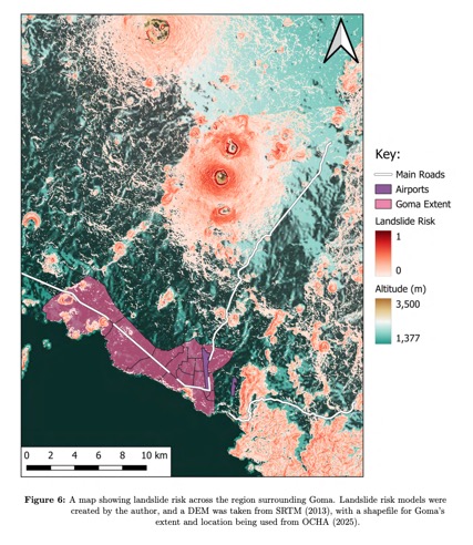
As Figure 6 demonstrates, there are also significant landslide risks across the region. Landslide risk is centred around both volcanoes, with Mt. Nyiragongo experiencing greater risk than Nyamuragira. This is primarily influenced by the steeper slope angles found around the volcanoes; particularly around the rims of their crater lakes; soil bulk density around the two volcanoes is actually higher (the more densely-packed soil particles are more cohesive, and therefore more resistant to failure). NDVI and NDMI (two other predictors of landslide risk used in this model) are also higher in the areas around the volcanoes, meaning the higher landslide risk is entirely slope-driven.
The Northern highway out of Goma also lies between two areas of elevated landslide risk to its East and West, having potential consequential impacts for aid.
Within Goma, landslides most prominently affect the Western areas of the city. The central areas of the city suffer relatively little risk from landslides, a fact mirrored for the larger of the two airports found in the region. These Western landslide hotspots are in fact driven by all four predictive factors; with steep slopes, lower soil bulk density, and low NDVI and NDMI. Each of these contributes to an increased likelihood of slope failure, and thereby an increase in landslide risk for these areas.
3.3. Limnic Eruption & Mazuku
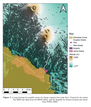
Modelling indicates that a limnic eruption could engulf the majority of Goma, affecting up to 2.5 million people (Jones, 2021). As shown by Figure 7, under a worst-case, maximum-volume eruption, only the furthest North-East and North-West regions of Goma would remain unaffected. This, however, is an unlikely scenario – much more likely would be a partial eruption – indeed, studies (Zhang and Kling, 2006; Bärenbold et al., 2020; Hirslund and Morkel, 2020) have shown that a full degassing of a saturated lake is unlikely – requiring highly saturated water, and little vertical stratification of gas concentrations. Indeed, the continued gas extraction from the lake has been cited as causing the lake to reach a near-stable state, with little change to CO2 or CH4 levels since 1974 (Bärenbold et al., 2020).
Although the informal settlements to the North of the city are less vulnerable, they could still be impacted; wind direction in Goma demonstrates distinct seasonality, most often coming from the South during summer, and from the North during winter (Weather Spark, 2024). Thus, a summer eruption could result in CO2 being blown further North, whereas the severity of a winter eruption could be lessened by the northerly wind most common during those months. It is important to note that, despite these seasons predominantly experiencing these wind conditions, daily conditions vary, not necessarily following these seasonal averages, making the impacts of an eruption dependent on that day’s wind conditions.
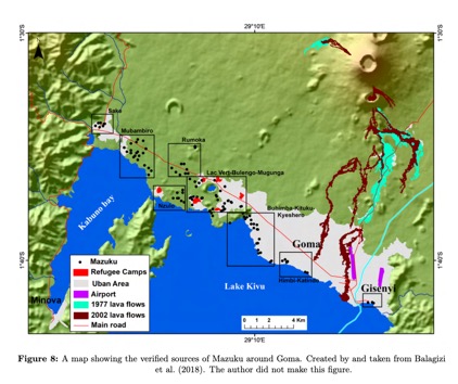
As shown by Figure 8, Mazuku is most prevalent in the Western side of the city, along the lakeside, and in the villages and refugee camps to Goma’s North-West. Data sparsity makes it difficult to spatially quantify the volume of gas being released at each of these locations, or indeed to determine the type of vent at each location: much of the data included here (from Balagizi et al. (2018)) is based upon verified in-situ measurements. In the past, these marked locations have been recorded with CO2 concentrations of up to 70%, far exceeding the lethal threshold of approximately 10% (Smets et al., 2010).
3.4. Earthquakes
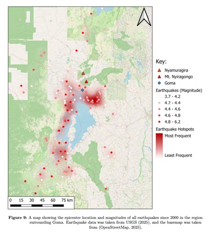
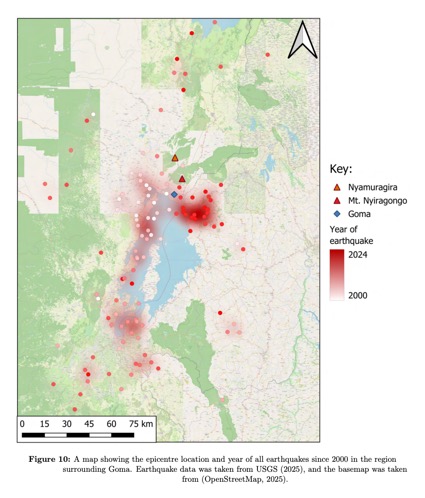
This region experiences frequent seismicity, with an average of 4.5 earthquakes above magnitude 2.5 (Richter scale) annually since 2000, as demonstrated in Figure 9 (USGS, 2025). Earthquakes had a mean magnitude of 4.5, with the most powerful being magnitude 6.2 in 2002, part of a period of elevated seismicity following the eruptions early in the same year (USGS, 2025). There is also a temporal pattern to the region’s seismicity; Figure 9 demonstrates how epicentres of the most recent earthquakes have primarily occurred in a hotspot to Goma’s South-East: a distinct spatial shift from those at the beginning of the data in 2000 to Goma’s West.
Seismicity in the region is primarily resultant from the presence of the East African Rift System (EARS). Goma is situated on the Kivu Rift, opening at a rate of approximately 2mm year−1, in a direction sub-orthogonal to the rift axis and a dominant normal faulting regime (Delvaux et al., 2017). This rift presents the region with regular shallow and predominantly low-magnitude earthquakes, although the volcanoes to the North create local volcanic dykes and fissures extending into the city and surrounding areas (Wauthier et al., 2012; Delvaux et al., 2017; Smittarello et al., 2022).
3.5. Tsunamis and Flooding
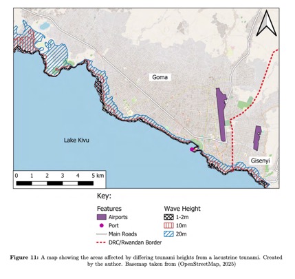
There are several examples of earthquake-induced lacustrine tsunamis in the historic record, with heights of up to 10m being recorded (Bussmann and Anselmetti, 2010). The examples used here were taken from Lake Lauerz and Lake Lucerne in Switzerland, both of which are significantly smaller than Lake Kivu. This could impact the applicability of these examples to the lake. There is also one case of a small lacustrine tsunami in Lake Kivu, following an earthquake in 2008, the height of which was not quantified (d’Oreye et al., 2011; Balagizi et al., 2018). The lake’s vulnerability to sub-lacustrine landslides also means that a larger tsunami could be generated from the low-magnitude earthquakes common in the region (Balagizi et al., 2018).
Figure 11 demonstrates the potential inundation of Goma under several different tsunami scenarios; a tsunami of 1-2 metres, of 10 metres, and of 20 metres. Given the city’s location in close proximity to Mt. Nyiragongo, much of the city is situated above the lake’s surface, leaving it out of reach of potential lacustrine tsunamis. The areas closest to the lake which would be affected in a tsunami event are infrastructure, such as the port, and several hospitals, such as Medical Center Cimak, located just West of the DRC/Rwanda border, or the Gisenyi District Hospital directly South of the Gisenyi airport. The Medical Center Cimak would be inundated under even the weakest of tsunami conditions assessed, whilst the Gisenyi District Hospital would be vulnerable to a ten metre wave. Likewise, the port would be vulnerable to all modelled tsunami heights, not to mention a significant number of hotels, residences, churches, and communities spread along the lake shore, all of which would be impacted by even a small lacustrine tsunami.
4. Discussion
4.1. Multihazard Interactions & Vulnerability
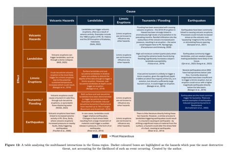
These results underscore the complex multihazard environment within which Goma is situated. Each of these models demonstrates the risks posed by individual hazards, but do not fully capture the true nature of the area’s overall risk profile, which is rooted in multihazard interactions. Figure 12 shows how each of these hazards can be affected by another, having serious implications for the events’ overall severity. The greatest risk posed by these interconnected hazards is almost certainly the possibility of a limnic eruption, triggered by a volcanic eruption from the fissures extending below Lake Kivu. Whilst monitoring does exist, and some measures are in place to manage the lake’s dissolved gas concentrations, this hazard is still under-monitored and under-managed (Balagizi et al., 2018). Pilot projects for degassing solutions, such as those offered by Limnological Engineering, have seen success in the lake, particularly in shallower areas with high CO2 concentrations such as Kabuno Bay, but more widespread degassing of the lake still remains purely theoretical (Jones, 2021). Other projects, such as KivuWatt currently provide electrical power for the surrounding population through methane extraction, but this is predicted to extract only 5% of the lake’s methane over the next 25 years. Other large-scale projects such as Shema Power Lake Kivu have been introduced, but the effects of which are yet to be quantified (MWM, 2025). Continued gas extraction from Lake Kivu is critical; with a worst-case limnic eruption affecting up to 2.5 million people, this hazard cannot be ignored (Jones, 2021). Other multihazard interactions, such as volcano-earthquake-landslide hazard chains also pose a threat to the city. For example, the 2021 eruption of Mt. Nyiragongo was followed by a significant period of elevated seismicity, with a notable 5.1 magnitude earthquake occurring directly beneath Lake Kivu (USGS, 2025).
Another factor which can compound the impact of a natural hazard is the vulnerability of the population. Vulnerability encompasses physical, social, economic, and environmental factors that affect the susceptibility of an individual, community, asset, or system to the impacts of hazards (UNDRR, 2017). These factors can be understood through the Pressure and Release (PAR) model, first proposed by Wisner et al. (2003), and later built upon by other research in many different fields (see De Stefano et al. (2015), Dube (2017), Burton, Rufat and Tate (2018) and Hammer et al. (2019)). Figure 13 demonstrates an adapted version of this model which can be applied to Goma. Notably, the legacy of colonialism and neo-colonialism as a root cause, arguably resulting in the region’s contemporary weak governance and political violence, significantly contribute towards the ‘pressure’ in the region (Wu, 2024). Indeed, Wu (2024) argues that the authoritarian power structures, ‘divide-and-rule’ tactics, and economic systems designed to be reliant on foreign economies induced by colonial rule have had a direct impact on political instability and violence across the continent, not least in the DRC.
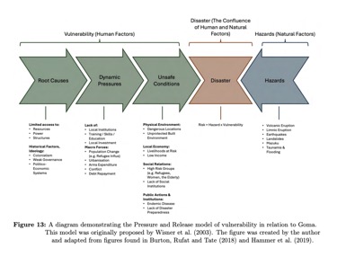
Goma’s largely low-income population, combined with political instability resulting both from internal conflicts in the DRC, and from unstable relations with Rwanda, increases the population’s overall vulnerability. Widespread low incomes significantly impact households’ capacity to cope with hazard impacts, particularly when rebuilding (SAMHSA, 2017). Furthermore, access to technology often used in early warning systems (such as mobile phone alerts) is restricted for low-income households (SAMHSA, 2017). Fothergill and Peek (2004) found that low-income areas tend to be worse prepared for a hazard event, citing prohibitively high costs. Indeed, Balagizi et al. (2018) report that much of Goma’s population regard natural hazards as less serious than ‘everyday’ issues such as food & water insecurity. Socioeconomic conditions within the city have also contributed to failures in hazard monitoring. Funding, provided by the World Bank, was cut for the Nyiragongo observatory in 2020 due to accusations of staff embezzlement, resulting in the observatory failing to predict the ensuing 2021 eruption, arguably exacerbating its impact (Holland, 2021; Thelwell, 2021).
There are also distinct inequalities in spatial vulnerability – Michellier et al. (2020) found that informal settlements (such as around Lav Vert or Muganga) to the North of the city experienced the most consistently high levels of vulnerability, with the furthest East and West areas of the city showing the highest absolute levels of vulnerability, as shown in Figure 13 (Michellier et al., 2020). This pattern is likely the result of several factors: firstly, areas outside the city centre are those which are fastest growing, often through the creation of informal settlements such as Lac Vert, which was created following an influx of refugees from Rwanda in 1994 (Michellier et al., 2020). Indeed, these settlements are often located in areas of high hazard prevalence, notably Mazuku, further increasing their vulnerability (Balagizi et al., 2018). Furthermore, Michellier et al. (2020) find that social vulnerability in the centre of the city, despite widespread low incomes, is moderated by high levels of hazard threat perception, fewer dependent individuals (such as women) in each household, and high levels of motorcycle ownership indicating increased economic capacity and greater mobility for evacuation in the case of a hazard event.
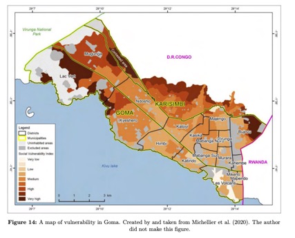
The Eastern half of Goma seemingly bears the greatest hazard burden, experiencing the largest levels of destruction from each of the three recent volcanic eruptions, landslide risks from several hotspots (particularly South of the Western airport), and recent seismic activity. Given the context of this area’s elevated vulnerability, this region should be targeted for stronger hazard mitigation measures. Landslide risk is also higher in several areas along the Western third of Goma, as is the prevalence of Mazuku vents, also coinciding with areas of increased vulnerability.
4.2. Mitigation Strategy
Any hazard mitigation strategy for Goma must address the complex interrelation between the multihazard environment and vulnerability in the city. It is difficult to directly mitigate many of this region’s hazards, so this report recommends that a hazard mitigation strategy should instead focus on vulnerability reduction and building community resilience.
This report’s first recommendation is the implementation of education schemes to inform the population about the varied dangers posed by the area’s varied hazards. Information campaigns focusing on, for example, the locations of areas previously affected by lava flows and the dangers posed by Mazuku vents, could provide a powerful tool for Goma’s population to make more informed decisions about where to live. Existing education campaigns in schools were found to be effective at increasing students’ awareness of the risks of recent volcanic eruptions, but failed to improve hazard awareness for other volcanic hazards which were not seen in the 2002 or 2021 eruptions (Mafuko-Nyandwi et al., 2024). Mafuko-Nyandwi et al. (2024) argue that sustained educational engagement, particularly in relation to hazards not seen in recent eruptions, is essential for these campaigns to have long-term effects.
However, providing information is insufficient if residents do not have the means to act upon it. Thus, this report’s second recommendation is to strengthen the region’s governance and support community mobility. This is impossible until the widespread disruption, damage and loss of life resulting from rebel activity is curtailed – once this has been achieved, targeted poverty reduction schemes focusing on the most at-risk areas identified (areas of both high vulnerability and hazard prevalence) should be implemented, to reduce the vulnerability disparities in the city.
Whilst strengthening the region’s governance and curtailing conflict in the area directly improves two of the key issues outlined in the PAR framework utilised here, mitigating the impacts of the region’s hazards must not be ignored. Effective early warning systems can drastically reduce the impact of hazard events, particularly in a complex multihazard environment such as Goma’s (Otuogha, 2024). Restoring funding for the Nyiragongo Observatory is an essential part of this strategy. Furthermore, the installation of additional monitoring equipment, particularly for Lake Kivu, the source of the most devastating potential hazard in the area, could greatly reduce the risk posed not only to Goma, but also the millions of others who live in the lake’s catchment area. Jolie (2019) suggest an integrated mapping approach for the monitoring of potentially dangerous lakes such as Lake Kivu. Whilst specifically tailored towards Ngozi Crater Lake, its methodology is still useful for application to other lakes. In particular, gas monitoring stations and thermal mapping, for example, are realistic, and should offer early-warning capabilities before an eruption (Jolie, 2019). Moreover, given Goma’s complex multihazard environment, the integration of each hazard’s monitoring network into a wider whole is critical for an effective overview of the broad spectrum of threats posed by hazards in the area.
Early warning capabilities are inconsequential without an effective way of alerting the local populace: therefore, this report’s fourth recommendation is the implementation of widespread announcement systems. One solution could be a tannoy system, much like those found in Illinois to provide early warnings for various emergencies (Kolios et al., 2016; Ready Illinois, 2023). Other simple and cost-effective strategies could include the distribution of radios to local community leaders, who would then have a responsibility to relay evacuation orders (for example) to the rest of that area’s population.
Finally, this report recommends a strengthening of infrastructure around key access routes to the city. The vulnerability of the highways and airports to landslides and lava flows, and the port to tsunamis or flooding would seriously impact both the ability of the population to evacuate, and the capacity for aid to enter the city following an event. There are many examples of mitigation for these hazards around the world: Iceland has successfully implemented lava barriers to redirect lava away from key infrastructure (Henley, 2024). Japan has successfully trialled self-powering sea gates to protect from tsunamis, and slope stabilisation nets are common worldwide to reduce landslide risk (Takagi, 2024; Rock Con, 2025). Whilst the fixed costs of this infrastructure is high, investment in infrastructure is widely recognised to be a strong catalyst for economic growth, providing long-term jobs and increasing the flow of money in the local economy (Alpert, 2023). Funding could be secured through international development loans, offered by many organisations such as the World Bank Group (2025) or the International Monetary Fund (2025). Seismic hazards can be effectively mitigated by introducing stricter building codes and strengthening existing infrastructure (Jackson, Copley and Priestley, 2021). In an economic climate such as that of Goma, however, the majority of the population lacks the resources needed to adhere to building codes, despite the necessity for mandating earthquake-resistant buildings. This presents a so-called ‘wicked’ problem – it is important to mitigate against hazards, but (particularly in low-income regions such as Goma) resources are limited – expending resources to improve building standards (including the retrofitting of existing buildings) prevents those resources from being used to, for example, create additional food banks or implement new vaccination programs (Steckler et al., 2018).
It is clear that – whilst there are no clear-cut solutions – by combining targeted education & poverty reduction schemes, improving local governance, strengthening infrastructure, and creating a comprehensive monitoring and alert network for the region’s complex hazards, Goma’s vulnerability can be reduced and its residents better prepared. Much like the region’s hazards, however, the impact of each of these recommendations is compounded when they are implemented together. In response to a complex multi-hazard environment, this report proposes a similarly interconnected multi-response plan, within which each of these recommendations, at least in part, is reliant upon the others to realise its full potential – education campaigns, for example, will be ineffective if Goma’s population still lives under the shadow of rebel violence.
5. Conclusions
This report has demonstrated that Goma is situated in a complex multihazard environment, threatened by volcanic eruptions, landslides, limnic eruptions, mazuku vents, earthquakes, tsunamis and flooding. The risks posed by these interrelated hazards are further compounded by the region’s endemic socioeconomic and political vulnerability, primarily driven by political instability and violence.
In the context of this complex web of hazard and vulnerability, this report underscores the recommendations of the Sendai Framework: the need for an integrated approach to hazard mitigation, focusing not only on mediating hazards, but also on reducing vulnerability and building resilience. Whilst this report was constrained by data availability and modelling limitations, future research – applying quantitative modelling and using more detailed data – could add further clarity to understandings of Goma’s complex and interconnected multihazard environment and how to mitigate against it.
References
Alpert, Gabe (2023). ‘Can Infrastructure Spending Really Stimulate the Economy?’ In: Investopedia. Online article. url: https://www.investopedia.com/articles/markets/080816/can-infrastructure-spending-really-stimulate-economy.asp (visited on 07/09/2025).
Balagizi, Charles M. et al. (2018). ‘Natural hazards in Goma and the surrounding villages, East African Rift System’. In: Natural Hazards 93.1, pp. 31–66. issn: 1573-0840. doi: 10.1007/s11069-018-3288-x. url: https://doi.org/10.1007/s11069-018-3288-x (visited on 04/03/2025).
Bärenbold, François et al. (2020). ‘No increasing risk of a limnic eruption at Lake Kivu: Intercomparison study reveals gas concentrations close to steady state’. In: PLOS ONE 15.8, e0237836. doi: 10.1371/journal.pone.0237836. url: https://doi.org/10.1371/journal.pone.0237836.
BBC News (2015). ‘DR Congo floods kill ’20 people in Kinshasa’’. In: BBC News. url: https://www.bbc.com/news/world-africa-35039545 (visited on 10/03/2025).
BGS (2025). Volcanic hazards. British Geological Survey. url: https://www.bgs.ac.uk/discovering-geology/earth-hazards/volcanoes/volcanic-hazards/ (visited on 10/03/2025).
Burton, Christopher G., Samuel Rufat and Eric Tate (2018). ‘Social Vulnerability: Conceptual Foundations and Geospatial Modeling’. In: Vulnerability and Resilience to Natural Hazards. Ed. by S. Fuchs and T. Thaler. Chapter. Cambridge University Press, pp. 53–81. doi: 10.1017/9781316651148. url: https://doi.org/10.1017/9781316651148.
Bussmann, Felix and Flavio S. Anselmetti (2010). ‘Rossberg landslide history and flood chronology as recorded in Lake Lauerz sediments (Central Switzerland)’. In: Swiss Journal of Geosciences 103.1, pp. 43–59. issn: 1661-8734. doi: 10.1007/s00015-010-0001-9. url: https://sjg.springeropen.com/articles/10.1007/s00015-010-0001-9 (visited on 08/03/2025).
CAFOD (2025). What is happening in Goma? The crisis in DR Congo explained. cafod.org.uk. url: https://cafod.org.uk/news/emergencies-news/dr-congo-crisis-fighting-in-goma (visited on 06/03/2025).
d’Oreye, Nicolas et al. (2011). ‘Source parameters of the 2008 Bukavu–Cyangugu earthquake estimated from InSAR and teleseismic data’. In: Geophysical Journal International 184.2, pp. 934–948. doi: 10.1111/j.1365-246X.2010.04899.x. url: https://doi.org/10.1111/j.1365-246X.2010.04899.x.
De Stefano, Lucia et al. (2015). Methodological approach considering different factors influencing vulnerability – pan-European scale. Technical Report. European Commission. url: https://www.researchgate.net/publication/331919810_Methodological_approach_considering_different_factors_influencing_vulnerability_-_pan-European-scale (visited on 07/09/2025).
Delvaux, Damien et al. (2017). ‘Seismic hazard assessment of the Kivu rift segment based on a new seismo-tectonic zonation model (Western Branch, East African Rift system)’. In: Journal of African Earth Sciences 134, pp. 831–855. doi: 10.1016/j.jafrearsci.2016.10.004. url: https://doi.org/10.1016/j.jafrearsci.2016.10.004.
Dube, Pauline (2017). ‘Barriers, needs and potential solutions to reducing vulnerability to global environment change for least developed countries in the Asia-Pacific Region’. In: APN Science Bulletin 7.1, pp. 20–26. doi: 10.30852/SB.2017.108. url: https://doi.org/10.30852/SB.2017.108.
European Space Agency (ESA) (2025). Harmonized Sentinel-2 MSI: MultiSpectral Instrument, Level-2A (SR). Google Earth Engine dataset. European Union / ESA / Copernicus. Available at: https://developers.google.com/earth-engine/datasets/catalog/COPERNICUS_S2_SR_HARMONIZED, accessed 19 August 2025.
Farquharson, Jamie I. and Falk Amelung (2020). ‘Extreme rainfall triggered the 2018 rift eruption at Kīlauea Volcano’. In: Nature 580.7804, pp. 491–495. issn: 1476-4687. doi: 10.1038/s41586-020-2172-5. url: https://www.nature.com/articles/s41586-020-2172-5 (visited on 10/03/2025).
Feuillet, Nathalie et al. (2006). ‘Stress interaction between seismic and volcanic activity at Mt Etna’. In: Geophysical Journal International 164.3, pp. 697–718. issn: 0956-540X. doi: 10.1111/j.1365-246X.2005.02824.x. url: https://doi.org/10.1111/j.1365-246X.2005.02824.x (visited on 10/03/2025).
Fothergill, Alice and Lori A. Peek (2004). ‘Poverty and Disasters in the United States: A Review of Recent Sociological Findings’. In: Natural Hazards 32.1, pp. 89–110. issn: 1573-0840. doi: 10.1023/B:NHAZ.0000026792.76181.d9. url: https://doi.org/10.1023/B:NHAZ.0000026792.76181.d9 (visited on 11/03/2025).
Gao, Bo-Cai (1996). ‘NDWI – A normalized difference water index for remote sensing of vegetation liquid water from space’. In: Remote Sensing of Environment 58, pp. 257–266. doi: 10.1016/S0034-4257(96)00067-3.
Getachew, Nega and Matebie Meten (2021). ‘Weights of evidence modeling for landslide susceptibility mapping of Kabi-Gebro locality, Gundomeskel area, Central Ethiopia’. In: Geoenvironmental Disasters 8.1, p. 6. issn: 2197-8670. doi: 10.1186/s40677-021-00177-z. url: https://doi.org/10.1186/s40677-021-00177-z (visited on 11/02/2025).
Google Earth Engine (n.d.). ee.Terrain.slope — Earth Engine API Reference. https://developers.google.com/earth-engine/apidocs/ee-terrain-slope. Last updated 6 October 2023; accessed 19 August 2025.
Google Maps (2025). Google Maps. Google Maps. url: https://www.google.com/maps (visited on 13/03/2025).
Hammer, Charlotte Christiane et al. (2019). ‘(Re-)conceptualising vulnerability as a part of risk in global health emergency response: updating the pressure and release model for global health emergencies’. In: Emerging Themes in Epidemiology 16.2. Open access; published April 8, 2019. doi: 10.1186/s12982-019-0084-3. url: https://doi.org/10.1186/s12982-019-0084-3.
Henley, Jon (2024). ‘Iceland volcanic eruption: barriers appear to hold back lava outside town’. In: The Guardian. issn: 0261-3077. url: https://www.theguardian.com/world/2024/mar/17/iceland-volcanic-eruption-barriers-reinforced-lava-grindavik (visited on 13/03/2025).
Hirslund, F. and P. Morkel (2020). ‘Managing the dangers in Lake Kivu – How and why’. In: Journal of African Earth Sciences 161, Article 103672. doi: 10.1016/j.jafrearsci.2019.103672. url: https://doi.org/10.1016/j.jafrearsci.2019.103672.
Holland, Hereward (2021). ‘Rising magma and empty coffers raise alarm for Congo’s volcano-watchers’. In: Reuters. url: https://www.reuters.com/business/environment/rising-magma-empty-coffers-raise-alarm-congos-volcano-watchers-2021-03-10/ (visited on 11/03/2025).
Hubert, Antoine (2005). The famous boiling lake. url: https://www.flickr.com/photos/atoll/182159061/ (visited on 10/03/2025).
International Monetary Fund (2025). ‘IMF Lending’. In: International Monetary Fund. Factsheet detailing the types, purposes, and mechanisms of IMF lending. Last updated April 2025. url: https://www.imf.org/en/About/Factsheets/IMF-Lending (visited on 07/09/2025).
Jackson, James, Alex Copley and Keith Priestley (2021). Increasing resilience to earthquake risk in developing countries. Feature article on Impact Map (University of Cambridge’s research outreach). url: https://impactmap.cam.ac.uk/increasing-resilience-to-earthquake-risk-in-developing-countries/ (visited on 07/09/2025).
Jolie, Egbert (2019). ‘Detecting gas-rich hydrothermal vents in Ngozi Crater Lake using integrated exploration tools’. In: Scientific Reports 9.1, p. 12164. issn: 2045-2322. doi: 10.1038/s41598-019-48576-5. url: https://www.nature.com/articles/s41598-019-48576-5 (visited on 11/03/2025).
Jones, Nicola (2021). ‘How dangerous is Africa’s explosive Lake Kivu?’ In: Nature 597.7877, pp. 466–469. doi: 10.1038/d41586-021-02523-5. url: https://doi.org/10.1038/d41586-021-02523-5.
Kakozi, Willy Missumba et al. (2023). ‘Determinants of knowledge, attitudes, and preventive practices for COVID-19 infection in Goma, DRC’. In: Advances in Health and Behavior 6, pp. 242–252. issn: 2630-466X. doi: 10.25082/AHB.2023.01.001. url: https://www.syncsci.com/journal/AHB/article/view/AHB.2023.01.001 (visited on 04/03/2025).
Kolios, Panayiotis et al. (2016). ‘7 – Data Dissemination in Public Safety Networks’. In: Wireless Public Safety Networks 2. Ed. by Daniel Câmara and Navid Nikaein. Elsevier, pp. 199–225. isbn: 978-1-78548-052-2. doi: 10.1016/B978-1-78548-052-2.50007-4. url: https://www.sciencedirect.com/science/article/pii/B9781785480522500074 (visited on 11/03/2025).
Komorowski, J-C. and K. Karume (2015). ‘Nyiragongo (Democratic Republic of Congo), January 2002: a major eruption in the midst of a complex humanitarian emergency’. In: Global Volcanic Hazards and Risk. Ed. by Charlotte Vye-Brown et al. Cambridge: Cambridge University Press, pp. 273–280. isbn: 978-1-107-11175-2. doi: 10.1017/CBO9781316276273.013. url: https://www.cambridge.org/core/books/global-volcanic-hazards-and-risk/nyiragongo-democratic-republic-of-congo-january-2002-a-major-eruption-in-the-midst-of-a-complex-humanitarian-emergency/EE7145DB04301FDF97555A1DF86834C4 (visited on 05/03/2025).
Li, Yangyang and Wenhui Duan (2024). ‘Decoding vegetation’s role in landslide susceptibility mapping: An integrated review of techniques and future directions’. In: Biogeotechnics 2.1, p. 100056. issn: 2949-9291. doi: 10.1016/j.bgtech.2023.100056. url: https://www.sciencedirect.com/science/article/pii/S2949929123000566 (visited on 06/03/2025).
Mafuko-Nyandwi, Blaise et al. (2024). ‘Building a prepared community to volcanic risk in the global south: Assessment of awareness raising tools for high school students in Goma, East DR Congo’. In: Progress in Disaster Science 24. Open access article published in December 2024, p. 100370. doi: 10.1016/j.pdisas.2024.100370. url: https://doi.org/10.1016/j.pdisas.2024.100370.
Michellier, Caroline et al. (2020). ‘Evaluating population vulnerability to volcanic risk in a data scarcity context: The case of Goma city, Virunga volcanic province (DRCongo)’. In: International Journal of Disaster Risk Reduction 45, p. 101460. issn: 2212-4209. doi: 10.1016/j.ijdrr.2019.101460. url: https://www.sciencedirect.com/science/article/pii/S2212420919308246 (visited on 04/03/2025).
MWM (2025). Shema Power Lake Kivu, Rwanda. Accessed: 2025-09-05. url: https://www.mwm.net/en/gas-applications/references/shema-power-lake-kivu-rwanda/.
Nakweya, Gilbert (2022). ‘How urbanization accelerates landslides in DRC’. In: Nature Africa. Bandiera_abtest: a Cg_type: Research Highlight Publisher: Nature Publishing Group. doi: 10.1038/d44148-022-00192-8. url: https://www.nature.com/articles/d44148-022-00192-8 (visited on 10/03/2025).
NOAA (2023). Tsunami Generation: Volcanoes | National Oceanic and Atmospheric Administration. NOAA. url: https://www.noaa.gov/jetstream/tsunamis/tsunami-generation-volcanoes (visited on 10/03/2025).
Nzanzu, Mahamba et al. (2021). ‘Household income and health care expenditure in Goma city, eastern Democratic Republic of Congo’. In: International Journal of Innovation and Scientific Research 57.2, pp. 65–80. issn: 2351-8014. url: http://www.ijisr.issr-journals.org/abstract.php?article=IJISR-21-237-16 (visited on 06/03/2025).
OCHA (2025). Quartiers de la ville de Goma (RDC) / Goma city’s quarters (DRC) | Humanitarian Dataset | HDX. url: https://data.humdata.org/dataset/quartiers-de-la-ville-de-goma-rdc-goma-city-s-quarters-drc (visited on 06/03/2025).
OpenStreetMap (2025). OpenStreetMap. OpenStreetMap. url: https://www.openstreetmap.org/ (visited on 13/03/2025).
Otuogha, A. Clarkson (2024). ‘Disaster risk reduction through early warning systems’. In: World Journal of Advanced Research and Reviews 23.3, pp. 177–186. issn: 2581-9615. doi: 10.30574/wjarr.2024.23.3.2521. url: https://wjarr.com/content/disaster-risk-reduction-through-early-warning-systems (visited on 13/03/2025).
Pierret, Coralie (2024). ‘In eastern DRC, the wounds of the genocide in Rwanda are still raw’. In: Le Monde. url: https://www.lemonde.fr/en/le-monde-africa/article/2024/04/11/in-eastern-drc-the-wounds-of-the-genocide-in-rwanda-are-still-raw_6668067_124.html (visited on 06/03/2025).
Program, Global Volcanism (2025). Nyiragongo (223030) in Volcanoes of the World (v. 5.3.1; 6 Aug 2025). Smithsonian Institution, compiled by Venzke, E. [Database]. doi: 10.5479/si.GVP.VOTW5-2025.5.3. url: https://doi.org/10.5479/si.GVP.VOTW5-2025.5.3.
Qin, Yigen et al. (2023). ‘Interaction of earthquake-triggered landslides and local relief: Evidence from the 2008 Wenchuan earthquake’. In: Landslides 20.4, pp. 757–770. issn: 1612-5118. doi: 10.1007/s10346-022-01996-3. url: https://doi.org/10.1007/s10346-022-01996-3 (visited on 08/11/2024).
Ready Illinois (2023). Outdoor Warning Sirens. Illinois State Government. url: https://ready.illinois.gov/plan/sirens.html (visited on 13/03/2025).
Rock Con (2025). Slope Netting for Enhancing Slope Stabilization. Rock Con. url: https://www.rockcont.com/application/slope-netting.html (visited on 13/03/2025).
Rouse, J. W. et al. (1973). Monitoring the Vernal Advancement and Retrogradation (Green Wave Effect) of Natural Vegetation. Tech. rep. RSC-1978-1. NASA Technical Report. College Station, TX: Remote Sensing Center, Texas A&M University, p. 93. url: https://ntrs.nasa.gov/citations/19740004927.
SAMHSA (2017). Greater Impact: How Disasters Affect People of Low Socioeconomic Status. United States Government. url: https://www.samhsa.gov/sites/default/files/dtac/srb-low-ses_2.pdf.
Sawyer G., M. et al. (2008). ‘Investigation into magma degassing at Nyiragongo volcano, Democratic Republic of the Congo’. In: Geochemistry, Geophysics, Geosystems 9.2, Q02017. doi: 10.1029/2007GC001829. url: https://doi.org/10.1029/2007GC001829.
Schnellmann, Michael et al. (2002). ‘Prehistoric earthquake history revealed by lacustrine slump deposits’. In: Geology 30.12, pp. 1131–1134. issn: 0091-7613. doi: 10.1130/0091-7613(2002)030<1131:PEHRBL>2.0.CO;2. url: https://doi.org/10.1130/0091-7613(2002)030%3C1131:PEHRBL%3E2.0.CO;2 (visited on 08/03/2025).
Seropian, Gilles et al. (2021). ‘A review framework of how earthquakes trigger volcanic eruptions’. In: Nature Communications 12.1, p. 1004. issn: 2041-1723. doi: 10.1038/s41467-021-21166-8. url: https://www.nature.com/articles/s41467-021-21166-8 (visited on 10/03/2025).
Shah, Arpit (2021). Landslide Hazard Mapping Workflows – Risk Modeling, Analysis & Detection. mapmyops (Main). url: https://www.mapmyops.com/landslide-hazard-mapping-analysis-and-detection (visited on 11/02/2025).
Sidik, Saima (2022). ‘Which Came First, the Eruption or the Landslide?’ In: Eos 103. issn: 2324-9250. doi: 10.1029/2022EO220094. url: https://eos.org/articles/which-came-first-the-eruption-or-the-landslide (visited on 10/03/2025).
Smets, Benoît et al. (2010). ‘Dry gas vents (“mazuku”) in Goma region (North Kivu, Democratic Republic of Congo): formation and risk assessment’. In: Journal of African Earth Sciences 58.5, pp. 787–798. doi: 10.1016/j.jafrearsci.2010.04.008. url: https://doi.org/10.1016/j.jafrearsci.2010.04.008.
Smittarello, D. et al. (2022). ‘Precursor-free eruption triggered by edifice rupture at Nyiragongo volcano’. In: Nature 609.7925, pp. 83–88. doi: 10.1038/s41586-022-05047-8. url: https://doi.org/10.1038/s41586-022-05047-8.
Song, Chuang et al. (2022). ‘Triggering and recovery of earthquake accelerated landslides in Central Italy revealed by satellite radar observations’. In: Nature Communications 13.1, p. 7278. issn: 2041-1723. doi: 10.1038/s41467-022-35035-5. url: https://www.nature.com/articles/s41467-022-35035-5 (visited on 08/11/2024).
SRTM (2013). Shuttle Radar Topography Mission (SRTM) Global. Distributed by OpenTopography. doi: https://doi.org/10.5069/G9445JDF. url: https://portal.opentopography.org/rasterOutput?jobId=rt1741104581100 (visited on 05/03/2025).
Steckler, Michael S. et al. (2018). The wicked problem of earthquake hazard in developing countries. Originally published via Eos – AGU. url: https://www.preventionweb.net/news/wicked-problem-earthquake-hazard-developing-countries (visited on 07/09/2025).
Steer, Philippe et al. (2014). ‘Erosion influences the seismicity of active thrust faults’. In: Nature Communications 5.1, p. 5564. issn: 2041-1723. doi: 10.1038/ncomms6564. url: https://www.nature.com/articles/ncomms6564 (visited on 10/03/2025).
Takagi, Hiroshi (2024). Self-powered movable seawall for tsunami protection and emergency power generation. PreventionWeb. url: https://www.preventionweb.net/news/self-powered-movable-seawall-tsunami-protection-and-emergency-power-generation (visited on 13/03/2025).
Taylor, Alan (2021). Photos: Lava Flows From Mount Nyiragongo. The Atlantic. url: https://www.theatlantic.com/photo/2021/05/photos-lava-flows-mount-nyiragongo/618976/ (visited on 10/03/2025).
Tazieff, H. (1977). ‘An exceptional eruption: Mt. Niragongo, Jan. 10th, 1977’. In: Bulletin of Volcanology 40, pp. 189–200. doi: 10.1007/BF02596999. url: https://doi.org/10.1007/BF02596999.
Thelwell, Kim (2021). Residents of Goma Return After Volcano Erupts. The Borgen Project. url: https://borgenproject.org/residents-of-goma/ (visited on 11/03/2025).
Tsongo, Esdras (2021). 8 emergencies we responded to this year. Concern Worldwide. url: https://www.concern.org.uk/news/8-emergencies-we-responded-year (visited on 10/03/2025).
UNDRR (2017). Vulnerability | UNDRR. United Nations. url: https://www.undrr.org/terminology/vulnerability (visited on 11/03/2025).
United Nations (2015). Sendai Framework for Disaster Risk Reduction 2015-2030. Geneva, Switzerland: United Nations. url: https://www.undrr.org/publication/sendai-framework-disaster-risk-reduction-2015-2030 (visited on 14/03/2025).
UNOSAT (2024). Lava flow and geological information related to the volcanic eruption in DR Congo and Rwanda as of 27 May 2021. url: https://unosat.org/products/3251 (visited on 05/03/2025).
USGS (2025). USGS Earthquake Catalogue. url: https://earthquake.usgs.gov/earthquakes/search/ (visited on 08/03/2025).
Wauthier, C. et al. (2012). ‘Magma sources involved in the 2002 Nyiragongo eruption, as inferred from an InSAR analysis’. In: Journal of Geophysical Research: Solid Earth 117 (B5). issn: 2156-2202. doi: 10.1029/2011JB008257. url: https://onlinelibrary.wiley.com/doi/abs/10.1029/2011JB008257 (visited on 07/03/2025).
Weather Spark (2024). Goma Climate, Weather By Month, Average Temperature (Congo – Kinshasa) – Weather Spark. Weather Spark. url: https://weatherspark.com/y/95901/Average-Weather-in-Goma-Congo—Kinshasa-date-Round (visited on 07/03/2025).
Wisner, Ben (2017). ‘“Build back better”? The challenge of Goma and beyond’. In: International Journal of Disaster Risk Reduction. Africa’s Urban Risk and Resilience 26, pp. 101–105. issn: 2212-4209. doi: 10.1016/j.ijdrr.2017.09.027. url: https://www.sciencedirect.com/science/article/pii/S2212420917302625 (visited on 09/03/2025).
Wisner, Ben et al. (2003). At Risk: Natural Hazards, People’s Vulnerability and Disasters. 2nd ed. London: Routledge. isbn: 978-0-415-25216-4. url: https://www.routledge.com/At-Risk-Natural-hazards-peoples-vulnerability-and-disasters/Wisner-Blaikie-Cannon-Davis/p/book/9780415252164.
World Bank (2022). Fact Sheet: An Adjustment to Global Poverty Lines. World Bank. url: https://www.worldbank.org/en/news/factsheet/2022/05/02/fact-sheet-an-adjustment-to-global-poverty-lines (visited on 07/03/2025).
World Bank Group (2025). Sustainable Infrastructure Finance. Overview of World Bank Group’s efforts to mobilise sustainable infrastructure financing, including tools, programs, and private sector partnerships. url: https://www.worldbank.org/en/topic/sustainableinfrastructurefinance (visited on 07/09/2025).
Wu, Yuning (2024). ‘Colonial Legacy and Its Impact: Analysing Political Instability and Economic Underdevelopment in Post-colonial Africa’. In: SHS Web of Conferences, Proceedings of the Asia-Pacific Management and Management Science Conference (APMM 2024). Vol. 193. EDP Sciences, p. 04016. doi: 10.1051/shsconf/202419304016. url: https://doi.org/10.1051/shsconf/202419304016.
Yuliza, E et al. (2016). ‘Study of soil moisture sensor for landslide early warning system: Experiment in laboratory scale’. In: Journal of Physics: Conference Series 739.1, p. 012034. issn: 1742-6596. doi: 10.1088/1742-6596/739/1/012034. url: https://dx.doi.org/10.1088/1742-6596/739/1/012034 (visited on 10/03/2025).
Zane, Damian (2025). ‘Trump and the DR Congo conflict: Could Kinshasa strike a minerals deal with the US?’ In: BBC News. url: https://www.bbc.com/news/articles/cjryjlndddpo (visited on 13/03/2025).
Zhang, Youxue and George W. Kling (2006). ‘Dynamics of Lake Eruptions and Possible Ocean Eruptions’. In: Annual Review of Earth and Planetary Sciences 34, pp. 293–324. doi: 10.1146/annurev.earth.34.031405.125001. url: https://doi.org/10.1146/annurev.earth.34.031405.125001.
#Write for Routes
Are you 6th form or undergraduate geographer?
Do you have work that you are proud of and want to share?
Submit your work to our expert team of peer reviewers who will help you take it to the next level.
Related articles
